 |
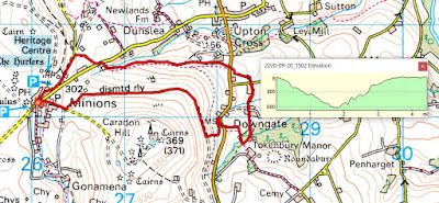
| Our route, which turned out to be just under 4.5 miles, started and ended in the car park at Minions. For a change, we headed down the Marke Valley back towards Upton Cross and then back around Caradon Hill on the old mineral railway track. As it's our duty to support local businesses, we ended up in the Cheesewring Hotel for refreshments - it was the least we could do. It was a walk that had it all - industrial archaeology, panoramic views, footpaths and green pasture land. |
 |
| The view from our starting point, with the stack and engine house of Wheal Jenkin in the foreground. Two communication towers on Caradon Hill in the background: the TV mast to the left and the military transmitter to the right. Wheal Jenkin was the mine at the top of the Marke Valley complex. This mining complex extended down what was previously known as Caradon Coombe but took the name of one of the prominent early investors in the mines. They were at their peak between 1830 - 1880ish and were major producers of copper and tin. |
 |
| A gnarled moss covered tree trunk. |
 |
| A shady footpath dropping down to the Marke Valley. I suspect that, one time, this was a route used by miners walking between the mines in the valley and the workings associated with the Phoenix Mine further up on the moor. |
 |
| My Risca butty in a buddle. |
 |
| It's definitely a good year for Rowan berries. |
 |
| Looking eastwards towards Sharpitor on the western fringe of Bodmin Moor. |
 |
| It looks like a sunken footpath and nowadays it is but it's actually a disused leat. Originally it would have taken water from the stream in the woods ahead and taken it down to a nearby farm. Water for animals? Power for a water wheel or a small mill? |
 |
| Every now and again the landscape opens up and is framed by a break in the hedgerows. Here we are looking in the direction of Dartmoor. |
 |
| I'm not above going along with photographic clichés. I'm not embarrassed to join the legions who have taken similar shots of dandelion heads. |
 |
| This is part of the mineral railway that fed the produce from the Marke Valley mines onto the line that came down from Minions. |
 |
| The stack and engine house associated with the Shaftsbury shaft. Exploring the remains will have to wait until another day when some of the vegetation has died back and the features are more discernible. By all accounts, there is a lot to see and generally potter around. |
 |
| Looking east from the 'normal' mineral track. Keen eyes will be able to pick out the towers of the churches at Linkinhorne, to the left, and South Hill, to the right. |
 |
| Late afternoon sun on the surface remains of Wheal Jenkin, framing those of Wheal Phoenix in the distance. |
 |
| Although without the geopolitical significance of borders elsewhere (think Mexico/USA or Isreal/Palestine), this stream forms part of the boundary between the parishes of St Ive and Linkinhorne. At one time, the formal beating of the parish bounds would have passed this way. Nowadays it's a place of isolation in what, purportedly, are some rather fine bluebells woods in season. |
No comments:
Post a Comment