Showing posts with label Cornish Coastal Footpath. Show all posts

Sunday, 7 May 2023

The last leg of the Cornish Coastal Footpath

Although we had walked stretches of the Cornish Coastal Footpath over the years, it was actually on 7th January 2010 that I recorded in my blog that we'd decided to make completion of the entire route, all 330 miles of it, an objective. We've duly recorded what we've done on a map, and through my blog, and, now, after 13 years, we finally managed to get around to walking the final leg. We think it's quite an achievement for two septuagenarians and I'll commemorate it with more photographs than usual.

The last leg began and ended in the car park of the Rectory Tea Rooms in Morwenstow, It was just over 5 miles, with half of it along the coast. The elevation profile gives a good idea of how up and downy the coastal stretch was, but it wasn't as bad as we were expecting. The midpoint of the walk, and where we turned inland, Marsland Beach, marks the border between Cornwall and Devon.
The footpath drops from the starting point through the graveyard of Church of St Morwenna and St John the Baptist. We'll visit this at the end of our walk.
The path through the woods was a delight as we walked between the bluebells and wild garlic, the pungency of the latter not to everybody's taste.
The reverse view was equally delightful. It's a great time of year for woodland flowers.
The characteristic pink of Sea Thrift (Armeria maritima) contrasts with the blue sea.
Looking up the coast towards Devon. Hartland Point is the furthest promontory. And the route is not as flat as it might look. This is the land of hanging valleys with steep sides. Hanging valleys mean lots of ups and downs.
The gorse was at peak flower, with a heady smell of pineapple.
More of the coastline.
If you look carefully at the horizon, you might just be able to make out Lundy Island.
Looking back on the way we came.
And looking forward to where we are going, dropping down to Littermouth and then going up those rather infamous steps, recently renewed to provide a safer route.
But before we tackled the steps..............
......we stopped for a cup of tea with a view.
Suitably refreshed, we ascended the staircase and all 191 of the steps. Yes, we were sad enough to count them. And, as we couldn't agree on the total, I've quoted mine.
At the top (and we weren't particularly puffed), we looked across to Marsland Cliff, comforted by the knowledge that we wouldn't have to climb this one. All we had to do was to drop down to Marsland Mouth, just over the edge, and then turn inland.
Flowing down to Marsland Mouth is Marsland Water and this is the border between Cornwall (right) and Devon (left).  And crossing from one county to the other marked our completion of the entire Cornish Coastal Footpath.
We celebrated our achievement in the most appropriate way possible - with a scone. Cream first in Devon.
Jam first in Cornwall. Between you and me, I prefer the Devon way as I regard the cream as a substitute for butter. Makes sense to me but it's a differentiation that is fiercely defended.
The shaded walk up from the beach through the Marsland Nature Reserve - a gift to the nation by one of the heirs of the Cadbury's chocolate fortunes. When the foliage is fully out, this must be a very attractive green tunnel.
Not that way, but this way or that way. We chose this way and headed around Cornakey Farm.
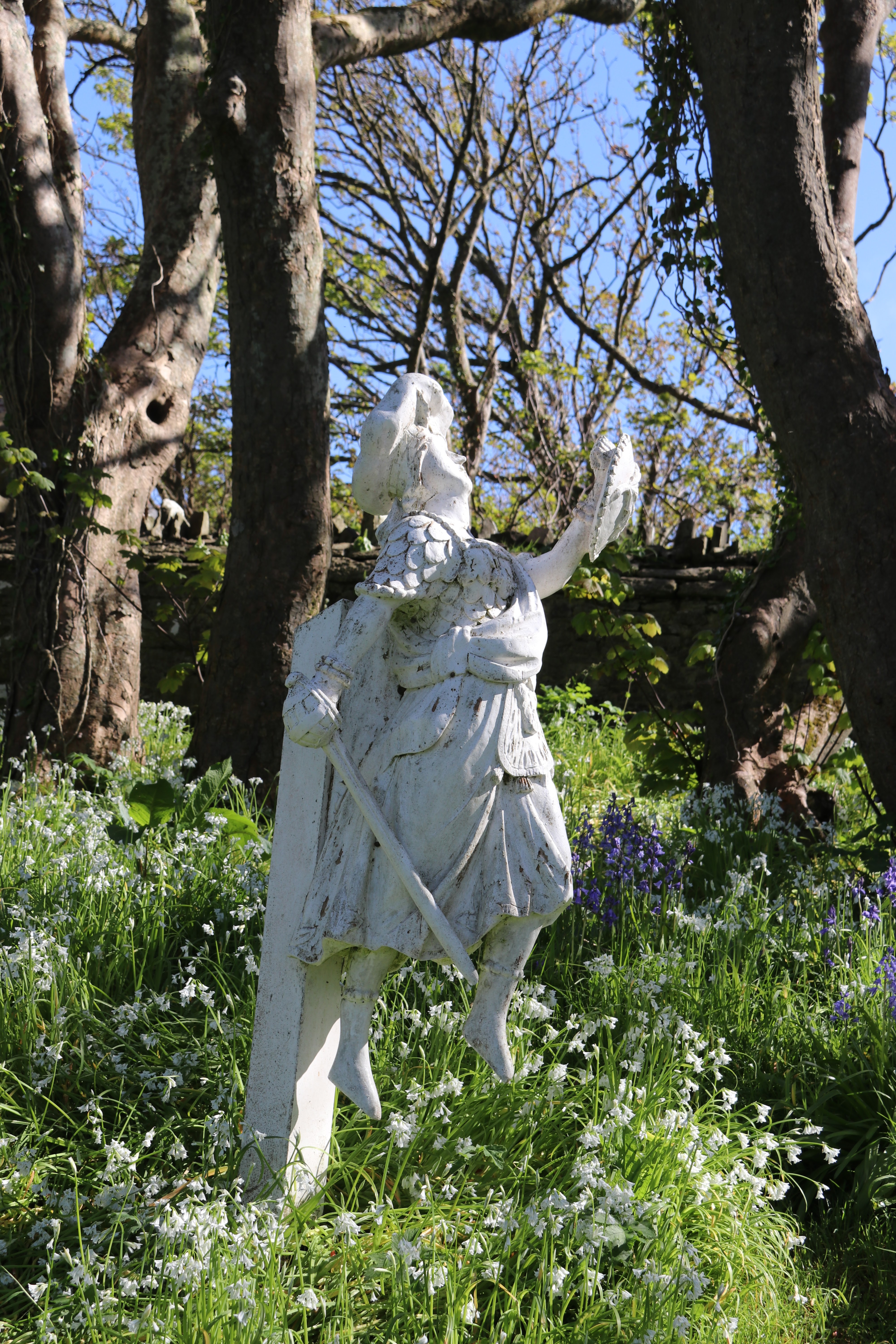
In July 1842 the Caledonia was bound for Gloucester having left Falmouth with a cargo of wheat. It floundered in heavy seas and was wrecked off Morwenstow. of Scottish snow which stranded near Morwenstow. The figurehead was formerly in the churchyard as a memorial to the wrecked crew buried there, but since 2008 has been restored and placed in the church for safekeeping, with a replica where the figurehead once stood. The vicar at the time of the wreck was Rev. R. S. Hawker

Of Norman origin (though there must have been an earlier church here), although restored in Victorian times, St Morwenna and St John the Baptist retains a fair amount of Norman work, notably in the porch and the north arcade.  And most famously, for 40 years from 1834, it had as its vicar the remarkable Robert Stephen Hawker. A poet and free spirit, who was responsible for much of the restoration of the church and who chose to bury shipwrecked sailors, of whom there were many in these dangerous seas, in his churchyard rather than, as was the custom at that time, on the shore where they were washed up.
 The doorway to the porch is a really fine example of Norman architecture. It includes zigzag carving and flowers carved in heavy relief.
A sober reminder to all who pass under the sundial and into the church = Life is like a shadow. 
The carved oak pew ends date from the mid 1500s and are in incredibly good condition.
Hooray, the Tea Rooms were still open! What better way to end a walk?  That's it done. Now we can go back and walk again the stretches that we really liked.

Sunday, 9 October 2022

Penultimate stretch of the Cornish Coastal Footpath.

This week's walk was a total contrast to last week's - Cornwall rather than Devon, coastal rather than moorland and as a couple rather than with a group. And rather special because this was the penultimate stretch of our circumnavigation of Cornwall via the eponymous Coastal Footpath. By the end of this walk, we would be left with a final stretch of 2-3 miles that would take us up to the Devon border at Marsland Mouth. But that's me getting ahead of myself, we had to get this one done first. Reputed to be some of the hardest miles to walk, and rated severe in all walking guides I've read, we were ready for a challenge. We were not disappointed.

The best way of doing this particular stretch was as a linear walk - my attempts at finding a reasonable circular route failed. So we parked at Morwenstow by the church, booked a taxi to take us to Sandymouth Bay and walked back from there. It came in at 5.3 miles. Sounds easy. But take a look at the elevation profile on the right. It says it all and any other comments from me would be superfluous. This was about half the distance of our previous walk and a reasonable estimate would put it at four times as much effort.
A glimpse of Sandymouth Bay just down from the cafe - their sausage baps are highly recommended as good preparation for a walk.
The geology in this area is unique and it's all down to the Bude Formation - a series of dramatic folds in the strata. Here, on Sandymouth Bay, are upstanding ribs of sandstone - a hard stone which is resistant to erosion. Those in the geological know will immediately recognise the anticline as the ribs plunge downwards towards the sea. 
Looking back towards Sandymouth Bay from the first incline on the Coastal Footpath - there were more to come.
A little further on and we were looking over Warren Gutter Beach. 
Next up was Duckpool, with more of the sandstone ribs. They come from the Upper Carboniferous era, or so I read. Geology really isn't my forte but I can recognise folds and ribs when I see them.
Looking down on Wren Beach.
Wren Beach from the east. And guess what that is in the middle?
Looking back down the coast westwards across Bude Bay towards Pencannow Point by Crackington Haven. Quite a view, eh? It's equally as good in the opposite direction as well. Lots of cliffs which means lots of ups and downs.
The satellite dishes of GCHQ Bude (formerly called the GCHQ Composite Signals Organisation Station, Morwenstow) are visible for miles around. This is a satellite ground station located at Cleave Camp, between the small villages of Morwenstow and Coombe, operated by the British signals intelligence service (GCHQ) with some heavy help of the USA. It's a listening post for telecommuncations of the highest military secrecy. It is on the site of the former World War II airfield, RAF Cleave, and you come across the foundations of some of these old building as you go by. There are currently some twenty one satellite antennae of various sizes. Given all this communication hardware, it comes as a bit of a surprise that there's no mobile phone signal in the vicinity. 
We came across a single patch of Common Toadflax (Linaria vulgaris), just before we dropped down to Stanbury Mouth. A little splash of colour in the otherwise barren edges of the footpath. The name Toadflax, by common consent, stems from the resemblance of the mouth of the flowers with the wide mouth of a toad. The general similarity of the plant in early summer to a Flax plant, accounts for the latter part of its name (hence Linaria from linum - flax). The light orange and yellow flowers also give it its country names of Butter and Eggs, Eggs and Bacon etc.
The footpath down from Harscott High Cliff, on the right, to Stanbury Mouth and Beach. And it was as steep as it looks. Climbing up to where I took the photograph was pretty steep as well. At an earlier point on the walk, we said to each other "this walk isn't as hard as we thought it was going to be". How wrong we were.
Looking towards the rather aptly named Sharpnose Point.
You can, if you wish, take the narrow footpath out to the end of Sharpnose Point but, given the rather strong winds at, we thought we'd reserve that for a calmer day.
There's no name on the map for this little beach but it's at the bottom of a cleave called Tidna Shute and the cliffs above are called Vicarage Cliff. These are where a past vicar of Morwenstow Parish walked and rode about. Our final ascent of this walk was up from the bottow of Tidna Shute to the top of Vicarage Cliff. Tough but we managed it. Not bad for two septuagenarians, if I say so myself.
And now for something completely different - the smallest building in the care of the National Trust. One of the most unusual surprises on the Coast Path is this little driftwood hut built by the eccentric Victorian vicar of Morwenstow, the Reverend Robert Stephen Hawker, who liked to smoke a pipe of opium here now and then with his literary pals Charles Dickens and Alfred Lord Tennyson. It is easy to understand why he chose this spot for it. There's room for three with their drug paraphernalia.
Hawker’ s Hut is known for its graffiti. Mostly it’s of a rather mundane nature (‘Charlie and Alfie wuz here’ sort of thing) but I really liked this one. ‘Correlation does not equal causation’. "Correlation is not causation", "Correlation is not causation", "Correlation is not causation" is a statistics mantra. It is drilled, military school-style, into the heads of every budding statistician. "Correlation is not causation" means that just because two things correlate does not necessarily mean that one causes the other. Despite it embodying a very important truth, the phrase has not caught on in the wider world. It's easy to see why. Our preconceptions and suspicions about the way things work tempt us to make the leap from correlation to causation without any hard evidence. Lazy journalism and unthinking analysis quite often ends up with "correlation must be causation" and that's why unfounded and misleading, even dangerous, false links are made. Try 'going to Eton produces intelligent politicians'.
The leaning tower of St Morwenna and St John the Baptist Church at Morwenstow. Not really. Not sure what went wrong there but it was good to see the church at the end of our walk.
But not as good as seeing that the Tea Rooms were still open! What better way to end a walk? Hopefully, we'll be able to celebrate here when we complete the last leg. That might even call for a full Afternoon Tea.


Wednesday, 25 May 2022

Oh, we do like to be beside the seaside

    Circumstances gave us an afternoon in Tintagel and we decided that we'd walk a shortish stretch of the Coastal Footpath. Tintagel as a village is not my favourite spot in Cornwall. It's far too busy and full of tat associated with King Arthur - Merlin Burger anyone? But the castle, and the new bridge, are well worth visiting when it's quiet. Best to go out of season. Or better still, do what we did and don't stop! Ignore me, I’m just an old curmudgeon. Go and enjoy yourself and why not buy a plastic sword and shield? Or a full-sized round table?

We started in the car park next to St Matriana's church on the outskirts of Tintagel. We've been there several times previously and it has some very interesting stained glass windows. But today was about walking and not spending too much time church visiting. Top tip: the car park by the church is free.
A straightforward 3 mile walk. Out of the car park, turn right and walk along the coast for about 2 miles. Then take a left and follow a few paths back to the church. 
A few steps from the car park and this is what in front of you.
If you look to the right, eastwards, you can see Tintagel ‘Island’ where the castle is. Look carefully and you can make out the hordes as they pick their way around the ruins. And spend more time dwelling on who wasn’t there than those who were.
If you look down, you can see drifts of Thrift and the amazingly blue sea.
And to the left - westwards - we can see across Port Isaac Bay with Gull Rock, off Trebarwith Strand, in the mid-ground.
Armeria maritima - thrift, sea thrift or sea pink. Extremely prolific along the coastal footpath at this time of year.
Another coast-scape looking east. The Youth Hostel at Tintagel can be made out. It has a spectacular view and all for a very reasonable fee (I assume).
At low tide, this is one long sandy beach. The Prince William pub at Trebarwith Strand can be made out in the distance. Good place for a drink with a view but a very steep descent to reach it. We skipped that this time around.
Swathes of Thrift along a bank.
A slate stile, some thrift and a dry stone wall with a herringbone pattern. Three distinctive features on this walk.
All along this stretch of coast are the remains of a series of slate mines/quarries. All long gone but these stacks stand testament to their presence. The stacks were formed when all the valuable slate was removed around them, leaving the core of harder, commercially valueless stone.
A few more stacks and a couple of ruinous mine buildings. At one time, the area would have resonated to the sound of the mines/quarries being worked. But all things must pass.
Wheatear on a rock. A lively little Summer migrant and there were lots of them flitting about.
A dry stone wall showing the herringbone pattern that comes from using relatively thin sheets of slate. Also called a Jack and Jill pattern.
The above in grey scale.
A rather ferocious guardian of a holiday let.