Showing posts with label Shetland 2018. Show all posts

Sunday, 20 May 2018

Shetland Sojourn 2018: Part 6

Our final full day on Shetland and, with the weather looking good, we headed off for a walk on a part of the Mainland that we hadn't visited before. An excellent finale to our stay and, for me at least, whetted my appetite for a return visit. There's something very special about the islands.
We decided to walk on Kettla Ness, a peninsular on the west of Mainland. It's on another island, West Burra, which is joined to Mainland via a causeway/bridge, to another island, Trondra. East Burra, the third of the Scalloway Islands, is joined to West Burra also by a causeway/bridge. Our walk, just over 5 miles, was simply around the peninsular.
Kettla Ness is joined to West Burra by a shingle tombolo to the south of the end of the road at Duncansclett, where we parked. The tombolo has been strengthened in places by metal gabions, presumably to stop the sea from breaching it in storm conditions.  The headland, or more properly the island of Kettla Ness, is currently uninhabited but is grazed by sheep.The beach on the north side of the tombolo (Banna Minn) is mainly silver sand but the beach on the southern side (West Voe) is comprised of pebbles.
Walking across the tombolo we came across this memorial stone. Intriguing and worth a closer look at the plaque.
It's a memorial to a Norwegian, Axel Eliezer Nielsen, a ship's carpenter.  He drowned in 1903 when the ship he was on (the barque Louise of Drammen) capsized off South Havra, a small island to the south east of Kettla Ness. It was erected by some of his descendants on 7th October 1996, specifically Harald Lansen, his great grandson, and Harald's children, Marthe and Alexander. Let's remember Axel.
A novel use for an old dinghy. Now, this is what I call a shed. Envy isn't a noble emotion but I'll confess to feeling it when I saw this. A practical solution to a roofing need as Timber is in short supply on these treeless islands,
Seascape with Rock Pipit. Or rather 'seascape without Rock Pipit'. The bird seems to have flown away at the crucial moment.
Seascape with Shag. Or rather 'seascape without Shag'. The bird seems to have flown away at the crucial moment.
At least this one didn't fly too far. Not a bad photograph this one - you can see the crest clearly and the yellow patch at the base of the beak. 
There's a long story behind the identification of this low lying flower as a very dwarf Danish Scurvygrass ((Cochlearia Danica). I couldn't place it and my reference books weren't much help. The next step was to ask my botanical neighbour, Mary, who wasn't certain and passed it to Cornwall's County Botanical Recorder, who passed it up the line to the national expert on cresses who was able to confirmed its identity. After all this, it is not a rare plant but, in this particular niche, was unusually small. And the name comes from the fact that, as a Scurvygrass, it contains high levels of Vitamin C and was used to prevent scurvy on board ships.
A seascape looking southwards. The guide for this walk was quite simple: keep the sea to your right and don't fall off the cliffs.
The band of intrepid explorers taking a break in the rain. Funnily enough, I don't remember it being as wet as it looks. Here's a frightening statistic for us to ponder on: when we five first met our combined ages were around 150 years, now we've pushed it up to 350. Where has the time gone? At what are we all looking at with so much admiration?
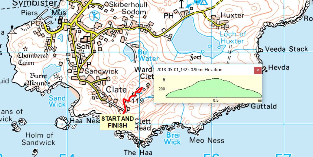
Why, it was another Vanessa trig point. This one has the number 10510 and is located at the top of the Ward of Kettla Ness. As with many trig points, the view was very impressive and well worth the uphill stretch to get to it. Although the visibility did not allow it, on a clear day you could get a line-of-sight view to the trig point at Sumburgh Head, which is exactly why it is where it is.
I've already mentioned planticrubs when we visited Whalsay. Here's one we came across towards the end of this walk. It had a net over the top and it looked as if it had been recently cultivated.
Not a pebble beach but an example of the construction of the walls in some of the deserted buildings on the Ness. A good example of making the best use of local materials. Go down to the beach, shovel up a load of shingle, add a little cement/mortar, pour the mixture into some shuttering and, voila, a wall.
North cottage, which is part of a late 19th and early 20th century crofting settlement, is currently used as a museum (sadly closed when we were there). It has a ‘taekkit (thatched) roof in the vernacular style.
The roof is thatched in straw, a traditional thatching material on the Shetland Islands (originally black oat straw). It is entirely netted using fishing net, which has been weighted with string and stones to keep it in place during the commonplace gales in these parts.
An almost-in-focus Dunlin standing on the edge of a lochan on Kettla Ness. My accompanying birder informed me that the dark underparts suggested that this was a sub-Arctic variant. Whatever the variant, I was quite happy just to have seen one so relatively close-up.
Just down the road from where we were staying was the abandoned crofting settlement of Fladdabister. It was occupied for several centuries and the crofters eked a living by farming and fishing. It was settled up until the 1930s. It was a somewhat eerie place to walk around in a sunny evening. This ruin intrigued me as the second floor rafter holes gave, by my estimate, a room height of about 5' 6". I presume the original inhabitants were fairly short - either that or they enjoyed banging their heads.
Just a stack of stones that caught my eye. I balanced a few on top in homage to whoever started it. Did it survive the next high tide, I wonder.
And that's it from Shetland. It was great seeing you. Maybe next time?

Monday, 14 May 2018

Shetland Sojourn 2018: Part 5

Sometimes a day doesn't go quite as anticipated but there's always a Plan B...
Let's take a plane to Fair Isle and spend the day there. Sounds easy enough but we hadn't factored in the weather. Unfortunately we arrived at Tingwall airport (airstrip more accurately) to find that our flight had been postponed until at least noon because of poor visibility. Added to that was the potential problem of all of the relevant safety crew at the airstrip on Fair Isle attending the funeral of a well respected member of the community there. No safety crew: no landing. Given our limited time, Plan B smoothly swung into operation and we decided to go to Fetlar instead. Visiting Fair Isle would be a good enough reason to return to Shetland at some future date.
Getting to Fetlar is a bit of an adventure in itself and involves a couple of ferries. We drove north on the Mainland to Toft and then took the ferry to Ulsta on Yell. The time for our connection to Feltlar meant driving at speeds exceeding the limit to get to our next ferry from Gutcha in the north east of the island. Yell itself is pretty barren in the interior with most of the activity taking place along the coast. To be honest, we didn't see anything on Yell that yelled at us to stop.
It takes about 30 minutes to make the crossing from Gutcha to Hamars Ness on Fetlar. A friendly ferry-man, who lived on Fetlar, was quite incredulous that we were going there for the day. "There's nothing there", he said. As you can see the weather was rather overcast, which didn't bode well for our visit. Fetlar itself is the fourth largest in terms of area in Shetland and has a population of just over 60. Currently there are just four pupils in the primary/junior school: for their secondary education children have to travel to Lerwick and board for 5 days of the week.
Nothing fancy, just a few more Greylag Geese seen from the RSPB hide at Funzie Mires, near the Loch of Funzie. Probably everyone with an interest in birds will have heard of this place as, at one time, it was the only place in the UK to see the Red Necked Phalarope. Phalaropes are a strange group of pot-bellied, long-necked, short-legged, needle-billed waders that prefer to be in the water, rather than at the edge. Strange in that phalarope females are more brightly coloured than the males who spend their time incubating the nests so need to be more camouflaged. Strange in that there is a role reversal that goes further than just plumage, females will compete for nest sites at breeding grounds, choose a male and then defend him against other females. Once the chicks arrive, the female leaves the male to raise them on his own. Girl power, eh? And we didn't see any as it was too early for them to arrive at this site.
Funzie Bay with Nousta Ness to the left. It was quite a breezy day and the waves were building up. Not a place to strip off and go for a swim.as this was the North Sea, synonymous with cold water.
On the way back to the car from Funzie Bay we came across this snipe lurking in the grass. It's a Common Snipe that has the wonderful Latin name of Gallinago gallinago. In fact this is a member of a  local sub-species, Gallinago gallinago faeroeensis, seen in Orkney, Shetland, Iceland and the Faroe Islands. The sub-species seen everywhere is Gallinago gallinago gallinago, a name almost longer than the bird.
Brough Lodge is a 19th-century Gothic mansion and is, to some, a rather romantic ruin overlooking the Colgrave Sound. But its origins have a sinister undertone as it was built by the Nicolson family, who were responsible for clearing Fetlar of many of its inhabitants (better use the land for sheep rather than people). It has been disused since the 1980s and, allegedly, the Brough Lodge Trust has recently started work to restore the building. I say 'alledgedly' because it seems that a lot of public money has gone their way with very little to show for it. Certainly there were signs of building having taken place but it was clear that nothing had been done for quite a while.
To the left of the lodge is a castellated folly built on top of the site of an ancient broch.
On the way back to the ferry I took the opportunity to 'bag' the trig point on Kirk Knowe. A standard Hotine column type built inside an old stone structure of some sort. There are 4 trig points on Fetlar, which strikes me as a lot for such a small place, and Kirk Knowe is the most accessible of these. I have read that some people go especially to Fetlar to 'bag' all four in a single day. Nice thought but there would have been mutiny in the ranks if I had suggested that.
The views from Kirk Knowe would, on a clearer day, be far reaching but today? Only as far as Brough Lodge, with the misty hills of Yell in the background.
Almost our own personal ferry as we made our way back from Fetlar to Unst, then to Yell and back to Mainland via the final ferry of the day (and have I mentioned the generous discounts for those over a certain age?). Once off the ferry at the Unst, we drove about 2 miles up the road and decided that the lure of fish and chips at Frankie's in Brae on the Mainland was irresistible. So we turned around, got back on the ferry and crossed to Yell. A mad dash across Yell got us to the terminal in good time to catch the next ferry across to the Mainland and then it was off to Frankie's. He did not disappoint.

Friday, 11 May 2018

Shetland Sojourn 2018: Part 4

Contrary to what I said in Part 2 of this series (here), the Whalsay ferry was not the one with a problem as we were trying tog et to Fetlar, more of which in a later post. Today, the actual Whalsay ferry performed brilliantly as we went to that island, previously unvisited by us, for the day. And, yet again, the weather was kind and A grand day was had by all.
The moon the previous night was, if not blood red, definitely pink. Try as I might, I could not get a faithful reproduction of its colour but this one will give you the gist of what it looked like.
On the ferry from Laxo to Symbister on Whalsay and this is the one going in the opposite direction. Each crossing takes around 30 minutes and they are scheduled to run approximately every 45 minutes or so. Turn up 5 minutes before they go and, if there's space, you'll get on. And, guess what? those over a certain age get tickets that are very generously discounted. IF I remember correctly, the fare for a car and five passengers was £13 return. Bargain.
Whalsay is off the east coast of Mainland Shetland and is roughly 5 x 2 miles. Its main industries are fishing and crofting and its population is just over a thousand people. For hundreds of years the local salt fish trade was in the hands of German merchants of the Hanseatic League. Ships from Hamburg, Bremen and Lubeck sailed to Shetland, particularly Symbister in Whalsay, every summer, bringing seeds, cloth, iron tools, salt, spirits, luxury goods and hard currency. Generations of the same families made the voyage and some merchants are buried in the islands. But it all came to an end when the Germans were forced out by import duties after the 1707 Treaty of Union between England and Scotland. Problems with Europe and import duties, eh? Doesn't that have a modern echo!
Once on the island we headed in a northerly direction (in fact, the only direction as there is but one decent road). In many places we came across these stone circular structures, not always by a loch - they seemed to be everywhere. We wondered if they were animal pens but found out that they were called 'crubs' locally and 'planticrubs' elsewhere on Shetland. They were, if you like, stone cloches to help raise plants by protecting them from the elements, prior to them being transplanted to their final quarters. How old are they? Something like this has been around for centuries. Sometimes they are covered in nets to keep birds away. To come completely up-to-date, what we call poly-tunnels down south are called poly-crubs on the islands.
Whalsay Golf Club and, as the sign says, it's Britain's most northerly golf club. An incredibly friendly and obliging member allowed us to use their toilets and kitchen facilities, even though the clubhouse was closed. I had an interesting chat to their part-time green keeper who had moved north from Cornwall a few years ago. He obviously loved the relaxed way of life up here and was glad to get away from the hordes of tourists that swarm over his home county during the summertime.
From the Golf Club car park, we did a 5-ish mile walk around Sponger Point and Skaw Tang. A classic sea shore walk with a few cliffs on the eastern side. In essence, we walked around the edge of the golf course. I think if I were a golfer playing here, I would find the views very distracting. But that may be a useful excuse for ineptitude!
The bay of Peat Geo, with a raft of gulls. At least three variants: Black Backed, Common and Herring.
The channel between Whalsay and the small island of Inner Holm of Skaw looks like it has some treacherous currents. A golfing hazard?
Typical of the scenery we encountered on our walk. Here's a thing that puzzled me as we went around. I know that golf courses have 'out of bounds' markers but is it really necessary to put markers next to the cliffs? Aren't they obviously out of bounds to all but the most adventurous (or foolhardy) golfers. And another thing: we wondered how many balls were lost because of the prevailing winds.
Given the frequency of flights to Whalsay - one every now and again - walking up the centre of the landing strip posed absolutely no hazard.
Lots of Turnstones around, showing their breeding plumage, although they only breed in the Arctic and are migratory in most parts of the UK. They are also known as Ruddy Turnstones because of their reddy-brown colouration.
On our way back to the ferry, two of us walked up to the highest point on Whalsay, Ward of Clett.
At the top we came across Trig Point 10523. Not your standard Hotine pillar but a Vanessa - a circular design seen in some sites in Scotland and Northern England. The standard pillar took about a ton of material to build and the Vanessa was introduced for the more inaccessible places in order to lessen the burden for the builders. 'Vanessa' is thought to be a corruption of 'Venesta', the firm that made the cardboard formers that were used. Venesa was chosen because they were manufacturers of toilet rolls, in a way the mini-version of the Vanessa.
Near the trig point were some long-abandoned military buildings (telecommunications of some sort. Why, oh, why can't the military clear up after they've left a place?). On the floor of one was this rather impressive piece of graffiti, although the term may be denigrating the effort that went into drawing it. It crossed my mind that it may be ritualistic in some way.
The Whooper Swan is a large white swan, bigger than the Mute Swans we see down south. It has a long thin neck, black legs and its black bill has a large triangular patch of yellow on it. It is mainly a winter visitor to the UK from Iceland, although a few pairs nest in the north.
Looking back to Symbister on our return journey. Like many such communities in Shetland, it was rather spread out. That large boat is one of the fishing fleet that still works out of the hardour.
Will ye no come back again? Maybe, one day. Look out for me.

Wednesday, 9 May 2018

Shetland Sojourn 2018: Part 3

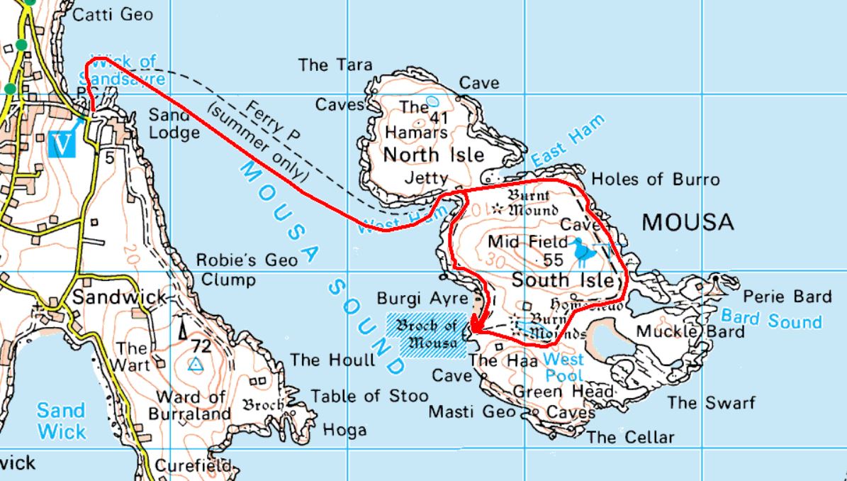
Another day of good weather and we decided to take the boat trip to the nearby island of Mousa. There are three reasons why this is a good place to go: firstly, it has the best preserved broch in Scotland, secondly, it is a good site for various birds; and, thirdly, it's a very pleasant place to stroll around.
Mousa is a small island just off the east coast of Mainland. Here's an interesting fact I learnt from somewhere: apparently the Vikings termed anything they could circumnavigate an island, even if they had to drag a boat overland for part of it. Hence Mousa was considered to be two islands - the North Isle and the South Isle. Mousa (“Mossy Island” in Old Norse) today is an RSPB Nature Reserve with important breeding colonies of seals and seabirds including the diminutive storm petrel, hundreds of which have made their home within the walls of the broch and even in the dry stonewalls that criss-cross the island.
As we waited for the ferry, we took a stroll along the coastal path, passed the 16th Century Sand Lodge, and came across a stone seat with this plaque attached. The least I can do is to show you Alan Slater's favourite view. And what a fine view it is, too, looking as it does towards our island destination.
And here comes the Mousa Boat, the Solan IV, to take us on the 20 minute crossing to the island.
Hee, hee, hee. Did you see the woolly hat that chap Parsons is wearing? He thinks it makes him look a rugged outdoors type. He's wrong. £3 from Tescos? He was robbed. Shall we go and crap on it?
Broch of Mousa (or Mousa Broch) is said to be the finest preserved example of an Iron Age broch or round tower. It is the tallest broch still standing and amongst the best-preserved prehistoric buildings in Europe. It is thought to have been constructed c. 100 BC.
It's about 50 foot high and has a single entrance. Because of its islaoted position it is thought to be relatively free from the ravages of time and those who thought it would be a good idea to use its stones for various building projects. It was thought to be used for a mixture of domestic and defensive purposes.
I've been to Mousa and my admiration for the skills of its builders increases with each visit. No mortar, just the skillful placement of local stones to make a structure that has withstood the vagaries of the Shetland weather for over 2000 years.
The thick walls contain a central passage that gives access not just to the roof but also a number of side-compartments, some used for storage and some used as living quarters.
From the top of the broch looking southwards with Sumburgh Head on the far horizon, probably some 20 miles away.
A pair of Eider Ducks. If you don't already know, guess which is the male.
A Great Skua, known as the 'Pirate of the Seas' because of its aggression. Getting too close to their territory generally results in a swooping attack on the unwary. This one was photographed at a suitable distance with a zoom lens because I had no wish to be pecked and I'm a great believer in self-preservation.
And this is the same bird in flight. They don't have many friends as they seem to spread panic wherever they go. Which is not surprising as they like nothing more than to snack on a tasty egg or, even better, a nice fresh chick. They really are nasty birds but are very adept at what they do.
A Shag drying its wings after what was, no doubt, a refreshing dip. How can I tell its a Shag and not a Cormorant? Amongst other things, the shape and colour of the base of its beak.
The day was completed with another trip to Sumburgh Head to see if the Puffins were still around. Hardly any on view this time so here's a shot from our previous visit. Actually, I think this is amongst the best of my Puffin shots so far. And it's in focus, Dai Phillips, it's in focus.