Friday, 2 February 2018

From Merrivale down the Walkham Valley

An impromptu walk with just two friends and it was out onto Dartmoor again. It's a walk we've done a couple of times previously but at different times of the year. Why do it? Because, as well as taking us through a wooded valley and open moorland, there's a lot of history to see, ranging from what some say is the most important Bronze Age site in Europe to early 19th century industrial archaeology. And it was the first walk I'd done with my brand spanking new GPS (a SatMap Active 20, thank you for asking).  So that was one thing less to moan about. Actually, there was absolutely nothing to moan about. Although it was a little cold and windy, we managed to avoid the rain, and that's always a bonus.
The route was just under 6 miles and was energetic enough to gives us a good stretch of the legs and exercise the lungs. We started in the car park at Merrivale, dropped down the Walkam Valley to Daveytown and Withill, thence through Crptor to reach the Old Railway by Swelltor Quarries. From there, we stayed on the track as it looped around King's Tor and then bore north to head across to Merrivale Down and back to our starting point. We didn't rush it and it took about 3.5 enjoyable hours.
From our starting point, looking north-east towards Mis Tor - there are actually two of them (Great and Little). It occurs to me that we've never actually walked up either one. We ought to as it's reasonably accessible and would do for a Sunday afternoon stroll.
The River Walkham in full spate, with an interesting collection of pipes taking water off for use elsewhere (contrast with the Long Ash leat mentioned later on).
No greenery in the canopy but plenty of green below.
Quite a few ponies around at various places on our way around. They have a great knack of looking at walkers with distain. For those who might be interested, pony sausages and burgers can be bought at the market in Tavistock. I kid you not.
Moss covered rocks everywhere, giving a lush verdant appearance to the woods.
The Mis Tors from a different angle. Keen eyes will pick out the red flag on the top indicating that the army firing range is being used, hence prohibiting access. Not that any sensible walker would want to risk being hit by a bullet. Having said that, some walkers seem to regard the flags as pretty decorations rather than a warning of dire consequences.
With all the rain we've been having, it came as no surprise to find some of the normal crossing points on streams unpassable, necessitating some rather difficult forays into the undergrowth to be able to cross without wading.
In the far distance we can make out Kit Hill. It's about 15 miles from where we were standing.
The spoil heaps of Swelltor Quarries. Long ago abandoned but stemming from the early 1800s. As ever, when I see activity on this scale, I can't but help thinking about the human cost. Just imagine - most of what is there was the result of muscle power.
It's amazing how trres are able to survive the piles of quarry waste. I'd be less surprised if the piles were just a couple of feet deep but these are towering stacks of granite. I wonder how deep the roots penetrate.
Coming around the King's Tor loop, we are faced with the old workings of the Foggintor Quarries, last worked in the 1950s. The track we are on was originally built as a horse-drawn tramway in the 1820s and later converted to a trackway for steam-driven locomotives. The line closed in the 1950s, coincident with the demise of the quarries that it served.
Trying to figure out the best way to cross this particular stream. And it wasn't the spot being studiously considered
On the edge of Merrivale Common is this standing stone. It's got T carved on one side.....
....and A on the other. Tavistock and Ashburton. This is an old guidestone, erected around 1700, to guide travellers to and from Tavistock and Ashburton, in the days before roads. There are only a few of these remaining at various points along the route. A forerunner of my GPS?  
And now we enter the area of the fantastic Merrivale Antiquities. There's stone circles, burial chambers, cairns, groups of hut circles, standing stones and stone rows. It never ceases to amaze. This is a site to tremendous significance and is a special place to walk through.
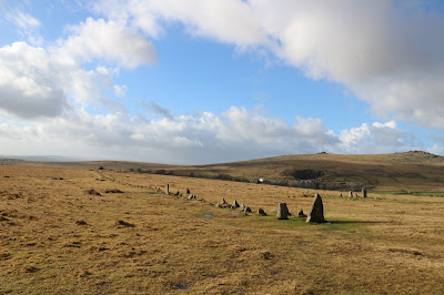
Looking down the southern of the two double stone rows. Each is about 1/2 mile long. What was their function? Nobody really knows. Ceremonial? Ancient chronometer? Tribal capital?
At the right time of day and in the right season, the stones cast strong and rather eery shadows. Do they have some significance to the function of the site? Many have speculated and there are many theories about alignments. Do I believe these theories? I haven't come across one that convinces me but I do believe that alignments within and outside these structures were both important and significant.
 
This large cist beside the southern row. “Cist” comes from “Kistvaen – a stone coffin, from the Celtic cist, a chest, and maen, stone,  ‘v’ being used as a mutation of ‘m’.” . It appears to have been intact until 1870, when the huge cover slab was split across the centre to make a pair of gateposts.
Talking of alignments, I was wondering whether the northern stone row alaigned with the TV mast on North Hessary Tor. If it did, would this mean that the ancients were interested in Coronation Street or Celebrity Big Brother? Fanciful, perhaps, but something to muse on.
The Long Ash Leat, built in the 1880's, that runs down between the stone rows and then takes water to Long Ash Farm. Compare this with the present-day utilitarian solution of metal pipes seen on the Walkham earlier. For many farms, the problem was not so much lack of water but getting it to where it was needed from deep ravines. In the absence of pumps, leats were a practical solution, albeit requiring a lot more effort. But let's not forget that labour was cheap way back.
Just a robin but a very friendly robin. Apart from the obligatory corvids, there was little in the way of birdlife to see. Lots of twittering in the trees but nothing that was visible enough for a photograph.


No comments: