Saturday, 16 October 2021

Regular Walks: Cotehele Quay and Danescombe Valley Circular

 A regular follower of the walks I describe has asked for more details of some of our more local routes. We quite often walk from Cotehele Quay and we consider ourselves lucky to have a number of variants that we can take depending on time available, mood, weather etc. Here's a 3.5 miler we did recently. With a refreshment stop at Cotehele Barn, it took around 2 hours.

We started at the quay car park, headed along the river track, up the Danescoombe Valley and then back to Cotehele through the woods on the 'top level' track.
We leave the car park and turn right along the river track to Calstock.  Possibly one of my least interesting photographs ever.
The area of low lying meadow just passed the car park is destined to become flooded wetlands as part of flood prevention measures. The embankment was broached a couple of weeks ago and it will be interesting to see how the wildlife evolves. I'm going to be involved in surveying the birdlife on a regular basis. At the moment, low tide just produces mud but give it a while and the waders will come as the flora and fauna stabilises to the new conditions.

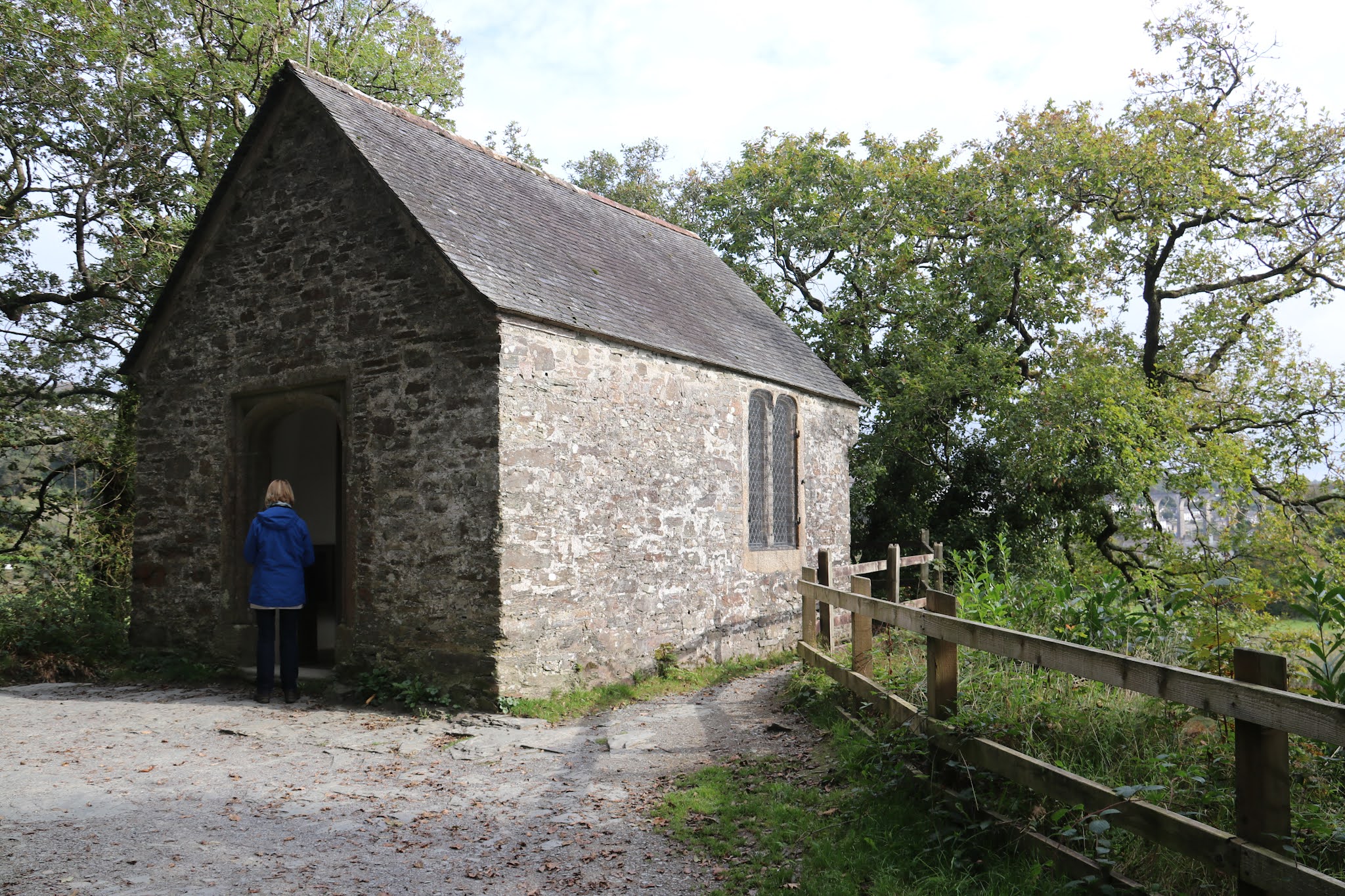
The first building we come to is The 'Chapel in the Woods', or, more properly, the Chapel of SS George and Thomas Becket, which was erected by Sir Richard Edgecumbe, the builder of Cotehele House. The story behind these bald facts is quite intriguing. In 1483 Sir Richard joined a rebellion against King Richard III. The rebellion was quashed, and the king's men under Sir Henry Trenowth of Bodrugan pursued Edgecumbe through the woods. He must have thought the end was near, but, thinking quickly, Sir Richard threw his hat upon the waters of the river that runs through the woods, and hid in the trees. His enemies saw the floating hat and assumed that Sir Richard had been drowned while trying to cross the water. They left, and Sir Richard was able to complete his escape and make his way to safety in Brittany. A few years later, Henry Tudor defeated Richard III at the Battle of Bosworth and took the throne as Henry VII. Sir Richard was able to return from exile and reclaim his estate at Cotehele. He wanted to give thanks for his escape so, sometime between 1485 and 1490 he built this small single-cell chapel at the spot where he had cast his hat into the river. The chapel measures only 6.3m by 4.6m and is built of coursed slate and stone rubble.

And then on to the look-out point taking in the view over the Tamar to the viaduct at Calstock. The word 'iconic' comes to mind. After taking it all in, continue on the track (up and down) and turn left when some houses are met.
A few yards up the track and you come to he old saw mill at the bottom of the Danescoombe Valley. Built in 1878, it was relatively short-lived and had gone out of use by the turn of the 20th century. It took its power from the stream that runs down the valley and, as it is at the bottom of the valley, it the lowest of the water-powered sites in the valley. A leat was taken off about 300 foot upstream leading to a cistern 30 foot above the mill. Water from this was piped to the turbine in the saw pit, but no evidence of this remains.
Head up the track for a while longer and you come across a group of houses associated with the 'local' mine, variously known as Wheal Calstock, the Danescoombe Valley Mine or Cotehele Consols. The first house was built in the early 19th-century as the mine office and the next housed a Cornish beam engine and was later reused as a blacksmith's shop on the ground floor, with a miner's dry (changing room) on the floor above. Both are available to rent from the National Trust.
A little further on and you pass the house called Mispickel, named after the arsenic containing ore that was mined here. The house itself comprises of two converted mine buildings and comes with its own adit and entrance to a silver mine.
Even further on, you come to a cluster of buildings associated with the Danescombe Mine, a former copper and arsenic mine, which was worked on and off throughout the 19th century. Its beginnings are obscure, but it was working before 1837 when it was restarted under leases granted by Lord Ashburton and the Earl of Mount Edgcumbe. This company was wound up in 1842. The buildings were leased off the National Trust in the 1990s by the Landmark Trust and extensively restored to form a unique holiday let.
The Engine House as it was before restoration. If you want to find out more take a look at the Landmark Trust website (here).
All along the path as it heads up there are the remains of various mining artefacts. This might have been a shaft. It's probably a good idea not to venture too far from the path and wander into the woods. Who knows what hole you might fall down?
Continue up the path until a lane is reached and then take the track immediately on the left. And this takes you to..........
.........Cotehele House, by a back entrance. A quick refreshment stop in the Barn Restaurant and it's time to head back to the starting point at the Quay.
There are a number of options at this point and one that we like is the one that goes through this tunnel and .......
.....into the Valley Garden, which drops down almost to the Chapel. We are just coming up to one of the best times of year for this stretch, when the autumnal colours are a joy to behold.

Monday, 11 October 2021

From Treverbyn Bridge

 This walk description has been languishing in my draft folder for a couple of months. I'm not sure why but here it is. It was a rather good one near St Neot on the western edge of Bodmin Moor.

This walk was around 6.5 miles and was a mixture of footpaths, open moorland and lanes. It began and ended at Treverbyn Bridge and headed up onto Berry Down. It was a reasonable trek up to the highest point but, as they say, it was downhill all the way from there. Some of the footpaths are clearly very old and have an undefinable feeling of leading from somewhere to somewhere else with serious intent. I can't really explain what I mean by this but walk them and you'll feel it for yourself.
Treverbyn Bridge has three arches and crosses the River Fowey on the road between St Neot, to the west, and St Cleer, to the east. Although now a minor road, this was the main medieval route linking the important market towns of Liskeard and Bodmin. The western part of the bridge contains pre-C15 fabric, which was referred to in around 1412 as ‘threatening total ruin’. Donations to the Church for the repair of bridges were common in early Christianity and in the medieval period, and ‘Indulgences’ issued by the Church guaranteed penance for sin for a certain number of days in exchange for labour or money to the repair of building of a bridge. In 1412 or 1413, Bishop Stafford, the Bishop of Exeter granted an Indulgence to fund the repair of Treverbyn Bridge, providing a pardon of forty days penance from sin for contributors. The carriageway was widened at each end of the bridge in the C18. The road lost its importance in the early C19 when a new turnpike was opened through the Glynn Valley to the south (the modern A38). The new bridge was built adjacent to Treverbyn Bridge in 1929, leaving the medieval structure for pedestrian use only.
The River Fowey looking rather tranquil, despite the recent rains. I suspect that the wild swimming loonies use this spot to indulge their masochistic tendencies. Little do they know, or probably care, about the dangers that lurk in these waters - contamination with various metals and nasty bacteria, to name but two.
At the hamlet of Lower Tranent we came across the old Bible Christian Methodist Chapel. It originates from the 1830s/1840s and was closed in 1963. The building is now used as the office for a camping and caravanning site. There are a couple of interesting facts about this chapel. Firstly, this Schedule II monument is listed as 'details unknown' - not even Mr Google can shed any light on it. Secondly, the chapel did not have a graveyard when it was first consecrated but one was later added when the local C of E church in St Neot refused to bury anyone who was baptised into the Bible Christian Sect. Sadly, the first person to take advantage of the new 'facility' was a 13 year old girl from a nearby farm.
I do like it when you get glimpses of the countryside through a natural window.
Look closely and you can just make out the 'steps' of the stile over this wall. I love walls like this and the way they blend in with their surroundings. They look as if they've been there for ever. There is also something very sensual about the softness of the moss and the fresh damp way it feels. These are good places to stop and spend a while to take it all in. Isn't this mindfulness? If so, try it without all the modern hype. You don't need lessons or a book, just the great outdoors and an open mind.
Sheltering from the rain in a conveniently located barn at coffee time.
Climb over the wall and this is the world you enter. Savour the green. Savour the contorted branches.
I stand to be corrected but I think this is a Common Bonnet fungus.
Ferns grow everywhere. Even on this clapper bridge just down a track from an old farm called Wortha. And by old, I mean circa 1300. We got that from the owner of the property himself. Apparently, until quite recently the only access to Wortha was directly from the moor and this lane did not exist.
A rather ragged Wall Brown butterfly. 
Not a great photograph but it's not often that I get to see a Green Woodpecker.
The magnificent Seven who were on this walk. On top of Berry Down.

The trig point on Berry Down. Formally, it's the trig point at Hut Camp Fort, taking its name from the nearby early prehistoric hillfort with outwork and outlying stone hut circle known as Berry Castle. Unfortunately the poor visibility and bracken growth conspired to obscure what was there to see. A case for a revisit? And the trig point? Apparently it is the 1837th most visited trig point on the Trigpointing.uk website. I suppose that gives it a certain cachet.

Yet another window on the world outside. This granite stile had some impressive mortice work to keep it in place.

Sunday, 10 October 2021

A wedding anniversary walk at Trowlesworthy Warren

October 9th 2021 - a very special day. It's our wedding anniversary. Well, sort of. Mr Google tells me that it's been 18,809 days since we walked up the aisle at St Mary's in Risca. Surely a cause for celebration and where better to be festive than Dartmoor? And where better than somewhere we haven't been before - the Trowlesworthy Warren area.

We parked near Cadover Bridge, that well known honey-pot for the good people of Plymouth, and headed up the track to Trowlesworthy Warren House. From there, we went onto the open moor and wandered through the collection of settlements on the side of the tors. We then ascended the slope to the tors and finally dropped down to the Plym, parallel to Spanish Lake (not a lake, but a stream). At around 4 miles, it was a good Saturday afternoon excursion.
And that’s where we were heading - Little Trowlesworthy Tor to the left and Great Trowlesworthy Tor to the right.
A glimpse of the River Plym as we set off.
A fine collection of abandoned and rusting vehicles at Trowlesworthy Farm. There has been a farm here since pre-Domesday Book and it looks as if some of the old tractors date from around then as well. The associated rabbit warren is generally accepted as the oldest warren on Dartmoor and has mediaeval origins. Within the boundaries of Trowlesworthy Warren are around 64 pillow mounds and 40 vermin traps scattered along the slopes of Little and Great Trowlesworthy Tors. The borders of the warren are defined by the natural rabbit defying waters of the River Plym, Spanish Lake and Blacka Brook.  
We came across the Lee Moor China Clay Leat several times. It runs from its take-off on the Plym to the 'Big Pond' and is approximately 2 miles long. It was built to serve the China Clay quarries, possibly as early as 1809.  Interestingly, it incorporates many narrow foot bridges over Trowlesworthy Warren and these are thought to have been placed to accommodate the rabbits of the warren. All such leats are a testament to the fact that, although there is plenty of water on Dartmoor, sometimes it takes a lot of effort to get it to where you want it!
A rather magnificent cloud formation over Great Trowlesworthy Tor.
 On the slopes of the Trowlesworthy tors are many buildings and structures which form a complex multi- period archaeological landscape, starting with the Bronze Age. The stone hut circle settlement complex is probably the most extensive we've come across on Dartmoor and includes at least 19 enclosures and 37 stone hut circles. 
Just two more of the hut circles. They really are substantial affairs and very impressive. It was good to sit amongst them and to savour the tranquility.  It is hard to imagine it 3,500 years ago dotted with settlements of neat round huts, with fields of crops growing near the river and herds of pasturing animals on the higher slopes; or, in mediaeval and later times, alive with the activity of rabbit farming and tin streaming.
An aerial view of the settlement areas. The circular boundaries and the hut circles are quite easy to make out, as is the dark line of the China Clay leat.


A Bronze Age stone circle just passed, and probably contemporaneous with, the stone settlements. There are eight stones in the circle and, unlike many, has not been 'restored' by any well-meaning, but ignorant, Victorian archaeologists. As ever, no-one knows its original function but we'll have to accept 'ceremonial' as a description. My alternative suggestion is that it was a place where Bronze Age teenagers could hang out and do their thing away from censorious eyes at the settlement.

Leading away from the circle are two stone rows, about 300 yards apart. They are a single row of about 50 stones running east to west and a double row (featured) comprising of over 100 stones, running north to south. At the head of each row, there is a stone cairn. Function? Again ceremonial and/or processional. Although it strikes me that it would be great fun weaving in and out of the stones on a Bronze Age scooter or mountain bike. Who knows?

In the distance are the China Clay workings that have been a feature of this part of the moor for centuries. In the mid-ground, you can make out the leat as it enters the final stages of its journey. Some find the dumps intrusive, I just accept them for what they are. Probably a view shaped by the many coal tips of my early years.
The impressive granite outcrop that makes up Great Trowlesworthy Tor. Mrs P leads the way.
Once around the tors, it becomes very obvious that they were quarried extensively and were particularly active in the early to mid-1800’s when the Pink Granite was extracted straight from the sides of the Tors. The Pink Granite was much valued because it was durable and could be polished to give a very attractive finish. 
The spoils of the quarries are clearly visible all over the place and there are many artefacts lying around.......
...........the most distinctive, and curious, of which is a rather large granite cylinder over 5 foot across. Apparently, back in the 1820s, there was a scheme to erect a large flagpole in Devonport (some say to indicate its independence from Plymouth) and a cylinder of granite was needed for its base. Here, at Trowlesworthy, a suitable boulder of Pink Granite was found and the stonecutters set to work shaping it. Unfortunately, by the time they had finished, the project had collapsed and it was surplus to requirements. So, for nearly 200 years, the cylinder has remained here, waiting for someone to find a use for it.
The China Clay leat again, contouring around the tors. The cleave you can just make out is where Spanish Lake runs. Why Spanish? Why Lake?Lake - simply because Lake is synonymous with stream, brook etc in this part of the world. Spanish - legend has it that it is connected with the threat of invasion by the Spanish as part of the Armada. Local residents hide their valuables in the peat hereabouts and waited for the threat to subside before retrieving them. But, did they? Another legend says that they didn't and that there's a fortune to be found, deep in the peat. Another good reason for watching where you tread?
My curiosity was piqued by this red bow tied around a branch of this hawthorn tree. Given the steepness of the bank, it would not have been an easy thing to do. Someone was very determined. A route marker perhaps?
The last half mile or so of the walk took us along the banks of the Plym, which was, rather surprisingly given our recent weather, rather tame. Look closely as you walk here and you’ll see lots of evidence of tin mining.
And for those who like the sound of running water, here’s a rather docile Plym. And it’s October 10th now, our 18,810th day anniversary. I’ll celebrate by making Mrs P a bowl of porridge.

Friday, 8 October 2021

A circular walk in the East Moor area of Bodmin Moor

A walk with friends in the East Moor area of Bodmin Moor. The weather was reasonable and by that I mean it was not lashing down with rain. It started off a little hazy but cleared up as the day proceeded. It's a part of the moor that I'm gradually growing very fond of. It has an isolated feel and is off the beaten track for many walkers and certainly an area by-passed by tourists. AS ever, a few photographs to accompany the description.
We started the walk at the Halvana Plantation, just down from EastMoorgate. A mixture of mature forestry and open moorland, the distance came in at 6.2 miles. The elevation profile is a little misleading as, apart from the last push to the top of Fox Tor, it didn't seem particularly hilly.
The Halvana Plantation has been here since the late 1920's/early 1930's and would be classed as 'mature coniferous woodland'. What is unusual is the fact that, unlike the dead undergrowth of most coniferous forests, here it is bedecked with moss and gives a glorious green.
Remember the Ents in Lord of the Rings? Here's one. Is it Treebeard?
Emerging from the plantation and looking towards Smallacombe Downs over the open moorland. Navigation is quite easy: head for the straggly trees to the left. It looks pretty featureless and, at one level, it is. But hidden amongst the lumps and bumps are Bronze Age hut circles and stone rows, evidence of granite works over the centuries, mediaeval villages etc etc. Lacking in topological features, perhaps, but a closer look reaps rewards.
Members of the group picking their way over one of the many small streams dropping down to a tributary of Withy Brook. It wasn't as wet as I was anticipating and it was quite easy to navigate a route without sloshing through mud and water.
An isolated farm called Rushyford Water, just up from Rushyford Gate. Mr Google failed me on this one and the only description I could find was that is was 'abandoned and unknown'. It has several walled fields associated with it and was obviously an 'intake' at one time. It isn't that big for a farmhouse and I'm wondering whether it was used seasonally, whilst animals were out grazing.  A sort of shepherd's hut? In the small outbuilding to the left, there is a small enclosed structure with no obvious function. It wasn't a fireplace but was it for storage? A well? A dog kennel like we see at Ditsworthy Warren?
Despite its small size, the main room of the 'house' had a sizable fireplace. It would have kept the place very toasty.
Looking from the 'front door' towards the north west (approximately) and Smith's Moor and Godaver Downs. Gradually the coniferous plantings are being replaced by native broad-leaved trees.
Just a frog.
A berry-covered hawthorn growing at the base of a beech and draped with hanging lichen.
Lots of evidence around here for granite working. Look closely and you can make out the drill marks on these pieces.

This part of Bodmin Moor is used extensively for grazing animals - sheep, cattle and horses. It's an area not widely visited - in fact, we've been here some four times and the number of people we've seen can be counted on the fingers of one hand - and that makes the cattle very curious and very wary. They soon move off if you get near them.
Work in progress? This massive piece of granite - it must weigh 1/2 ton or more - has been split but not taken away. Just imagine the effort that went into all the drilling and splitting. And all to no avail, as it remains where it was worked. No longer needed? I hope whoever did it got paid.
Looking back to whence we came as we head up Fox Tor. Featureless? Nah. We've just gone passed a few ring cairns and hut circles.
Heading up to the trig point on Fox Tor.
And here is the trig point. Apparently it's the 889th most visited trig point in the UK. Fancy that.
Not quite the Beast of Bodmin but a local inhabitant in his cosy den.
'His and hers' chairs with a view? I can imagine that this would be a great spot for taking in the sunset.
The merry band of walkers on top of Fox Tor. Although my hat looks as if it was modelled on that of a Papal Nuncio, it merely shows how strong the wind was. My setting out the camera for a remote shot is always cause for amusement.