Thursday, 17 May 2018

Venford Reservoir Walk in the sun

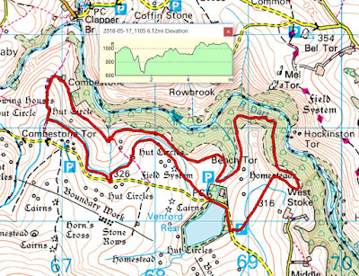
When the sun is shining, where better place to walk than Dartmoor? And today we did just that, with a 6 miler starting and ending near Venford Reservoir. It's a walk that we've done at least a couple of times before and, as with so many of our walks, it's one that bears repeating. Venford was originally built to provide a water supply for Paignton and is set in an area of the moor full of antiquities, hut circles, cairns and stone rows. Take a look at the map below and it will give you an idea of what I mean. It's been described as an hidden gem as it really is tucked away and you only realise that it's there until you are almost on it. A day for taking my new camera body on an outing, so there are more photographs than usual.
Our route from the car park took us up over a stretch of moorland and then down into the West Dart Valley. Once there we headed west until we came to Combestone Farm and then back along the Hamlyn Leat to our starting point. Not entirely flat with a couple of lung-testing bits thrown in for merriment.
Heading out onto Holne Moor. Lots of gorse around and, for most of the walk, the accompanying call of the cuckoo.
Looking west-ish towards Cox Tor and Princetown.
Now we are starting to descend into the West Dart Valley until.....
.....we reached the pipeline track and headed west along this. I call it the pipeline track because it is the route of the pipe taking water from the reservoir to Paignton. In its way, it's performing the same function as the traditional Dartmoor leats, taking water from the moor to where it is needed.
How green is my valley? Extremely green at this time of year, with everything bedecked in moss, ferns and the remnants of bluebells.
Even the trees have moss on them, resulting in green in both horizontal and vertical planes. A very pleasing, all-embracing affect.
There were a few patches of bluebells still around, but not enough en masse to give a carpet of blue.
Lunch stop by a babbling brook, not that there are many brooks on Dartmoor. There are plenty of streams but very few brooks. Off the top of my head, I can only think of Rattle Brook.
Some decaying bract fungi well past their prime but still standing out against the green background.
 A clapper bridge that, I suspect on no grounds whatsoever, is not that old. Perhaps contemporary with the mines in the area? Circa 1830 - 1850?
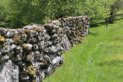
I like this stretch of stone walling because it seems, to me, that it is really bedded into the landscape. Of course, being covered in moss helps in this regard. At around this spot, we thought we saw a stoat but it very quickly scuttled off. If indeed it was a stoat, it was a rare sighting and a shame that the camera didn't capture the moment.
Just a section of the aforementioned wall. Built of 'moorstone' - taken from the fields and incorporated into the wall without any shaping. Good enough for keeping stock confined.
Our final mile or so was along the Hamlyn leat, originally built to take water to various mines and mills. Look into the distance and you can make out the line of the leat as it contours around Combestone Tor.
The leat serves many purposes, including providing a drink for the many ponies on this part of the moor.
As I mentioned earlier, there are lots of antiquities in these parts but most are not as easily discernible at this Bronze Age hut circle. Give it a few more weeks and it will be hidden by ferns.
Just a hawthorn tree, shaped by the prevailing wind coming from the west.
I'm glad they put a name plate on this because I was struggling to decide what it was. A very colourful addition to a cottage garden.
The nearby village/hamlet of Holne has an excellent community shop and tea room - just the place to head for after a walk. I was rather surprised that they had a 'DNP Information Point' with no pictures of me on display. I soon remedied that and now it's a proper 'DNP Information Point' and will tell visitors everything they need to know about me - and less.

No comments: