Thursday 16 January 2020

A few days at Trevaunance Cove #2: Bays, coves and Poldark

We've walked a few miles on the Coastal Footpath over this break, all of it we've done before. But, because of the passage of time and/or walking it in different seasons or directions and/or just plain memory loss, it all seemed fresh to us. Walking it feeds the senses and the soul

We had to leave the cottage early as our choir was singing at the funeral of one of our members, the delightful and much missed Francis Gardiner. To make the most of our time down west, we did one last walk on our way back.
One last look at Trevaunance Cove before we depart and head for home. Not a surfer in sight.
On the way back we managed to fit in another circular walk. This was just under 5 miles and took us to Holywell Bay, Porth (Polly) Joke and Crantock Beach. A nice mix of scenery with lots of sweeping vistas. The weather was clear but quite windy in places.
A memorial plaque to someone affixed to a bench is a common sight but plaques to dogs are something I've never seen before. As well as rabbiting on this area, called The Kelseys, perhaps the dogs run amok on the sands of Holywell Bay, our next stop.
  One of Holywell Bay’s most distinctive features are the twin rocks just off the coast. These two huge rocks are known as Gull Rocks or Carter’s Rocks and the twin islands are instantly recognisable in many beach scenes in Poldark. Apparently, the beach represents the Warleggan's beach next to Poldark's Nampara. Each series, or so I'm told, seems to have several shots featuring Gull Rock and Ross galloping along the sands.
Gosh, talk about us being lucky. We were on the beach just in time to see some of the Poldark cast at leisure. And here they are...……………...
"Oi, George Warleggan, get orf my wave. And, bleddy Demelza, where are you off to?"
"Tis too bleddy cold for Mrs Ennis and me, Ross. We're off for a pasty and a cakey tea."
The way out of Holywell Bay involves ploughing through some extensive sand-dunes which is not a fun exercise. However, the views make it worthwhile. The next cove along from Holywell is Porth Joke, also known as Polly Joke. The name, Polly Joke, is thought to be derived from the Corhish Pol-Lejouack meaning Jackdaw cove. It's a rather secluded place and there is no road or car park nearby, which means that relatively few people visit it.
Standing on Pentire Point West, looking across Crantock Beach towards Pentire Point East and the island known as The Goose. There is another avian-related island, The Chick, just down the coast off Kelsey Head. Beyond Pentire Point East lies Newquay, a place we try to avoid whenever we can. Too busy for most of the year and not a patch on St Ives.
An infra-shot of Trevaunance Cove. Not really convinced by the way the colours have come out.
This one is better but low light levels do not bring out the best of IR.
A field of cabbages which would look really good in larger format IMHO.
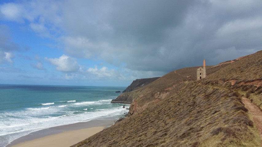
Wheal Coates.

A few days at Trevaunance Cove #1

We've just had a short break in Cornwall. Cornwall? Don't you live in Cornwall? Well, yes we do, but we like Cornwall and what's better to do than spending time on the coast? And with the advantage of having to drive for only just over an hour before we get there! This time Trevaunance Cove, near St Agnes, 'twixt Perranporth and Portreath, was our base, in a cottage overlooking the cove.
On the way down we stopped off at Perranporth for a stroll along the sands and a drink. It's a 'dog friendly' beach so there were lots of people around exercising their pets but the presence of so many canines did not detract from its raw beauty. The last time Mrs P and I were here, we had to wade around the point to avoid being cut-off by the incoming tide. The moral of that story? Always check the tide tables before taking a short cut along the sands. All this time later, I'm still not sure that Mrs P has forgiven me for that lapse of judgement.
Whilst down here, we did three walks. Walk 1 (6+miles) took us eastwards, up the Coombe Valley and inland back to St Agnes. Walk 2 (another 6+miles) took us westwards along the coast to Chapel Porth and then inland back to St Agnes around St Agnes Beacon. Walk 3 (2.5 miles) was an inland loop from Chapel Porth - the high winds kept us off the coastal footpath. A very enjoyable trio of walks, with varied scenery and lots of fresh air. 
Walk 1: Looking back into Trevaunance Cove. The pile of rocks on the beach in the mid ground are the remains of the ill-fated harbour. Rebuilt three times over the centuries and always destroyed by the sea. It's hard to believe that once this area was heavily industrialised due to the activities of numerous mines and quarries. Look closely and you can make out our red Qashquai outside of the cottage we were renting. Not the best we've had but it was OK.
Walk 1: Heading inland from Barkla Shop along a muddy stretch of woodland. There's nothing quite like a bit of slippery mud to get the calf muscles working hard. Not true, as walking up sand dunes is worse.
The position of our cottage meant that, just a few yards across the lane, we had a bird's eye view of the cove and its surfers, who were there on every incoming high tide. Your typical St Agnes surfer seemed to be a 40+ male. I did not see any female surfers and very few youngsters.
It is quite a spectator sport but not for me as the water's far too cold - at all times of the year. I could be persuaded to have a sneaky admiration for those who do but my primary thought when I see them is "bloody daft".
Walk 2: The area around St Agnes is riddled with mining remains - ruined engine houses, vegetation-covered wheel pits and buddles etc. Several of the shafts of the various mines are still open, but covered with "Clwyd Caps", which are the pyramidal wire meshes seen here.
Walk 2: This really is a stunning part of the North coast and has been recognised as such by many film makers over the years. The most recent of these are those responsible for Poldark. St Agnes Head seen here portrays Nampara Valley in certain shots. I will add that any references to Poldark are based on what I've read and heard - I've never watched any episode from end to end and, to be honest, I only watch to irritate Mrs P with my snide comments about the plot and the acting.
Walk 2: Looking towards the west, over the expansive sands of Porth Towan. At low tide, it is possible to walk from Porth Chapel to Porth Towan. With our Perranporth adventure very much in mind, it's not something I'd suggest to Mrs P without careful studying of the tide tables. Wherever and whenever you walk along the Coastal Footpath, you are accompanied by the sound of crashing waves and tumbling surf - wonderful. Apparently, the cliff top paths way down on the left have been used to film Ross Poldark on some of his many (many, many, many) galloping scenes.

Walk 2: This part of the coast is dominated by the ruins of Wheal Coates. Earliest records indicate a mine at the site since 1692. The present mine opened in 1802 and was closed in 1889 when the price of tin fell. It came into full production in 1815.  Flooding and bringing ore to the surface were the main problems of the mine until steam-driven equipment was available, as the mine's underground operations extended for some distance under the sea. The mine was sold in 1844 and thereafter allowed to flood. A new owner reopened the mine in 1872 but work was sporadic until its 1889 closure. For some years, the yield was 20lb of tin per ton of ore. In 1906, new ownership hoped to work the mine for both tin and copper as Wheal Coates had produced a small amount of copper ore, more than a century earlier. At the height of its production, 140 people were employed at the site to mine a seam of tin just below sea level but this and a subsequent period of operation from 1911-1913 were not very successful because tin production was sporadic. The mine was closed for good in 1914 and is now looked after by the National Trust.  
 
Picture
Walk 2: Here we are looking back toward Wheal Coates with the Towanroath Shaft engine house in prominent view, possibly is one of the most photographed places in the county. Taking the wide path to the engine house, you really feel that you are walking in the footsteps of the miners that worked here some 200 years ago. And then you get thinking about the atrocious conditions they worked in and the pittance they were paid. If you are not careful, you could fall off the cliff in anger.
Walk 2: Every now and again, you come across something unexpected and poignant. This was in one of the narrow paths coming off St Agnes Beacon into the town. All we have to do nowadays is to turn the tap and think no more about it. But that's not the case for countless millions around the world and young girls still have to trek miles to get water supplies.
Walk 2: Back at Trevaunance Cove for the evening light.
What I like about this shot are the changing colours of the water - from blue to green to grey.
The only people we saw actually going in for a swim. I don't think they stayed in very long. Who can blame them? Certainly not me.
Walk 3: The sea at Chapel Porth. Not a lot here apart from the National Trust car park and a seasonal café. Out of season, it's a very quiet spot. In season? That's another matter. Avoid, avoid, avoid.
Walk 3: Bad weather and the caution that comes with advanced years took us inland for our third walk. The route was simple: park at Chapel Porth, walk up Chapel Coombe and then come back via the top of the coombe. All the way around we were walking through what was Great Wheal Charlotte, also known as Wheal Charlotte. This is a long abandoned copper and tin mine and all that is left now is the wall and door arch of the engine house and an adjacent fenced-off mine shaft. The mine opened in 1806 and was originally called North Towan. After operating profitably for a period, it was renamed Wheal Towan; however, the mine closed shortly afterwards. It opened again in the late 1820s, and was renamed New Charlotte and after that Great Wheal Charlotte. In 1877 it was renamed Charlotte United. The engine house held a 60 inch pump and was built in 1828. The main shaft was 82 fathoms (approximately 500 feet) deep and was next to the engine house. But the surrounding area is dotted with other shafts, many of which are capped with clywds, others are just marked with posts. Tread carefully!
Looking across Chapel Porth beach towards Wheal Coates and St Agnes Head. This gives a better idea of the extent of the mining complex. Getting 20lbs of tin from a ton of ore gives a good idea of how much processing was needed and how much waste material was produced.
The incoming tide at Trevaunance, with Storm Brendan beginning to have an impact. We spent ages just staring out to sea and enjoying the breakers. Simple pleasures which, luckily, we both share.
Watching this pair cavort around the beach was an interesting diversion to watching the waves. If I ever got a dog, this would be the type I'd go for.
Not quite the lone surfer but he was one of just two who braved the conditions. Having said that, he and his mate seemed to spend most of their time bobbing up and down, rather than grabbing a ride. What, we wondered, makes one wave more rideable than any other?

Wednesday 1 January 2020

New Year's Day 2020: Ditsworthy Warren

Happy New Year to anyone who reads this. 2020 and the start of a new decade. And what better way to start the year off than with a bimble on Dartmoor? Nothing quite as ambitious as our last walk along the Cornish Coastal Footpath, just a gentle stroll near Sheepstor. Bimble? That, apparently, is the term used for what we did. Another one for Scrabble enthusiasts? You see, reading this blog can be educational.
We took a circular route to Ditsworthy Warren House, a short way up the Warren itself and then back along the track that leads to the Eylesbarrow mine complex. At just over two miles, nothing too taxing but nonetheless enjoyable for that.
At this time of year, the moor looks rather barren, with just the dead bracken adding a splash of colour.  This area featured in the film War Horse or so I've been told. It's not one that I've watched, I'm afraid.
Ditsworthy Warren House, which is starting to look rather neglected. Once the home of the warrener and his family, it is now very occasionally used as a bunkhouse by the army for troops on exercise. It is isolated, although a popular destination for walkers, and atmospheric. Warrener? He who looked after the warrens and the rabbits contained therein.
Once upon a time (actually it was circa 1972) we found one of these on the moor and took it back to the flat we had in Plymouth. There we painted it with luminous paint and put it on display in our lounge, where it featured with a foil-covered mannequin's head and a unwanted toilet. Oh, to be young and daft again. Our tastes have matured over the years. Or, more accurately, Mrs P's have and mine have probably remained pretty much the same.
A few shots with my IR-adapted camera that give a slightly different perspective on the landscape.
Ditsworthy Warren House looking very bleak. I like this one as it looks like it felt.
The building to the right, to be found immediately in front of the Warren House, was where rabbits were hung prior to them being shipped off to wherever they were being sold. Plymouth market? Destined for the navy in Devonport via the Royal William Yard?
The skull in glorious IR.