Sunday, 27 May 2018

Our life in cars: Part 3

My third and final post on the cars in my life. The first post covered the cars we had when we were a single car family and the second covered those cars that were 'non-company', that is, we paid for them ourselves. And now we come to the series which includes, but is not restricted to, some cars provided by the companies I worked for.
A confession: of all the cars we have owned over the years, this one is my favourite: a Citroen 2CV. Powered by a massive 649cc air cooled engine, with a gear stick that stuck out of the dashboard, front brakes that you could see (and replace) when the bonnet was opened, sliding windows and door opening by courtesy of a pull string. And it's crowning glory, the fabric roll-top roof. If you want thrills, try driving along the outside lane of the M25 at 70mph in windy conditions. A white knuckle experience. In those pre-Health and Safety days, it was possible to drive with the roof 'down' and the children standing on the back seat with their heads exposed to the elements. Happy days. It was my final pre-company car and it was downhill from there on.
From the ridiculous to the sublime: from a 2CV to a Rover 2000. A car with electric windows, sunroof and a host of other 'useful' features. And a ride like sitting in an armchair on wheels.
In fact, we liked this model so much that we went for something identical when we were allowed to change the car - in those days we could change vehicles every 20,000 miles. And this was before company cars were classed as 'taxable benefits'.
Our next change took to us to our first four wheel drive - a Ford Maverick. The thing I remember about this one is that it was surprisingly unstable at cornering, with the back end being rather wayward even at modest speeds.
We now progressed to a big beast, an Isuzu Trooper. Seven seats, which were useful on many trips with our children and their friends. It introduced us to one of our lifelong vices - a liking of heated front seats! It was a manual change with a ferociously powerful clutch. So much so that a back operation made driving it very difficult and lead to a premature change of model.
Our next one was a Mercedes C200 and our one and only automatic, due to my back operation. A wonderfully comfortable car with, guess what, heated leather front seats. Our vice was indulged big time. We did over 120,000 miles in this and I took it with me when I left full time employment - not as a freebie, I would add. We parted with it when the gearbox started rattling and there were traces of water in the engine oil.
The demise of the Merc lead us to the Volvo V40 Estate. Lots of room and lots of gadgets. An altogether pleasant driving experience which we enjoyed so much....
.....that we exchanged for another one. Sadly this one ended up in a front end shunt (not our fault) and was written off as beyond economical repair by our insurance company. A shame really as it had a good few miles still in it.
From the Volvo, we moved onto a Passat 2TDi Estate. Bought with 25,000 miles on the clock, we sold it at 120,000. Not trouble free motoring, but it was certainly comfortable and roomy.
And this brings us to our latest, a Qashquai TDi. With as many gizmos, beeps and driving aids (it's even got radar in the front) as the 2CV didn't. But will I look back on it with the same fondness as I do for the 2CV? Time will tell.

Sunday, 20 May 2018

Shetland Sojourn 2018: Part 6

Our final full day on Shetland and, with the weather looking good, we headed off for a walk on a part of the Mainland that we hadn't visited before. An excellent finale to our stay and, for me at least, whetted my appetite for a return visit. There's something very special about the islands.
We decided to walk on Kettla Ness, a peninsular on the west of Mainland. It's on another island, West Burra, which is joined to Mainland via a causeway/bridge, to another island, Trondra. East Burra, the third of the Scalloway Islands, is joined to West Burra also by a causeway/bridge. Our walk, just over 5 miles, was simply around the peninsular.
Kettla Ness is joined to West Burra by a shingle tombolo to the south of the end of the road at Duncansclett, where we parked. The tombolo has been strengthened in places by metal gabions, presumably to stop the sea from breaching it in storm conditions.  The headland, or more properly the island of Kettla Ness, is currently uninhabited but is grazed by sheep.The beach on the north side of the tombolo (Banna Minn) is mainly silver sand but the beach on the southern side (West Voe) is comprised of pebbles.
Walking across the tombolo we came across this memorial stone. Intriguing and worth a closer look at the plaque.
It's a memorial to a Norwegian, Axel Eliezer Nielsen, a ship's carpenter.  He drowned in 1903 when the ship he was on (the barque Louise of Drammen) capsized off South Havra, a small island to the south east of Kettla Ness. It was erected by some of his descendants on 7th October 1996, specifically Harald Lansen, his great grandson, and Harald's children, Marthe and Alexander. Let's remember Axel.
A novel use for an old dinghy. Now, this is what I call a shed. Envy isn't a noble emotion but I'll confess to feeling it when I saw this. A practical solution to a roofing need as Timber is in short supply on these treeless islands,
Seascape with Rock Pipit. Or rather 'seascape without Rock Pipit'. The bird seems to have flown away at the crucial moment.
Seascape with Shag. Or rather 'seascape without Shag'. The bird seems to have flown away at the crucial moment.
At least this one didn't fly too far. Not a bad photograph this one - you can see the crest clearly and the yellow patch at the base of the beak. 
There's a long story behind the identification of this low lying flower as a very dwarf Danish Scurvygrass ((Cochlearia Danica). I couldn't place it and my reference books weren't much help. The next step was to ask my botanical neighbour, Mary, who wasn't certain and passed it to Cornwall's County Botanical Recorder, who passed it up the line to the national expert on cresses who was able to confirmed its identity. After all this, it is not a rare plant but, in this particular niche, was unusually small. And the name comes from the fact that, as a Scurvygrass, it contains high levels of Vitamin C and was used to prevent scurvy on board ships.
A seascape looking southwards. The guide for this walk was quite simple: keep the sea to your right and don't fall off the cliffs.
The band of intrepid explorers taking a break in the rain. Funnily enough, I don't remember it being as wet as it looks. Here's a frightening statistic for us to ponder on: when we five first met our combined ages were around 150 years, now we've pushed it up to 350. Where has the time gone? At what are we all looking at with so much admiration?
Why, it was another Vanessa trig point. This one has the number 10510 and is located at the top of the Ward of Kettla Ness. As with many trig points, the view was very impressive and well worth the uphill stretch to get to it. Although the visibility did not allow it, on a clear day you could get a line-of-sight view to the trig point at Sumburgh Head, which is exactly why it is where it is.
I've already mentioned planticrubs when we visited Whalsay. Here's one we came across towards the end of this walk. It had a net over the top and it looked as if it had been recently cultivated.
Not a pebble beach but an example of the construction of the walls in some of the deserted buildings on the Ness. A good example of making the best use of local materials. Go down to the beach, shovel up a load of shingle, add a little cement/mortar, pour the mixture into some shuttering and, voila, a wall.
North cottage, which is part of a late 19th and early 20th century crofting settlement, is currently used as a museum (sadly closed when we were there). It has a ‘taekkit (thatched) roof in the vernacular style.
The roof is thatched in straw, a traditional thatching material on the Shetland Islands (originally black oat straw). It is entirely netted using fishing net, which has been weighted with string and stones to keep it in place during the commonplace gales in these parts.
An almost-in-focus Dunlin standing on the edge of a lochan on Kettla Ness. My accompanying birder informed me that the dark underparts suggested that this was a sub-Arctic variant. Whatever the variant, I was quite happy just to have seen one so relatively close-up.
Just down the road from where we were staying was the abandoned crofting settlement of Fladdabister. It was occupied for several centuries and the crofters eked a living by farming and fishing. It was settled up until the 1930s. It was a somewhat eerie place to walk around in a sunny evening. This ruin intrigued me as the second floor rafter holes gave, by my estimate, a room height of about 5' 6". I presume the original inhabitants were fairly short - either that or they enjoyed banging their heads.
Just a stack of stones that caught my eye. I balanced a few on top in homage to whoever started it. Did it survive the next high tide, I wonder.
And that's it from Shetland. It was great seeing you. Maybe next time?

Thursday, 17 May 2018

Venford Reservoir Walk in the sun

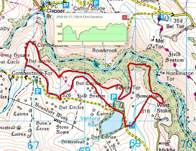
When the sun is shining, where better place to walk than Dartmoor? And today we did just that, with a 6 miler starting and ending near Venford Reservoir. It's a walk that we've done at least a couple of times before and, as with so many of our walks, it's one that bears repeating. Venford was originally built to provide a water supply for Paignton and is set in an area of the moor full of antiquities, hut circles, cairns and stone rows. Take a look at the map below and it will give you an idea of what I mean. It's been described as an hidden gem as it really is tucked away and you only realise that it's there until you are almost on it. A day for taking my new camera body on an outing, so there are more photographs than usual.
Our route from the car park took us up over a stretch of moorland and then down into the West Dart Valley. Once there we headed west until we came to Combestone Farm and then back along the Hamlyn Leat to our starting point. Not entirely flat with a couple of lung-testing bits thrown in for merriment.
Heading out onto Holne Moor. Lots of gorse around and, for most of the walk, the accompanying call of the cuckoo.
Looking west-ish towards Cox Tor and Princetown.
Now we are starting to descend into the West Dart Valley until.....
.....we reached the pipeline track and headed west along this. I call it the pipeline track because it is the route of the pipe taking water from the reservoir to Paignton. In its way, it's performing the same function as the traditional Dartmoor leats, taking water from the moor to where it is needed.
How green is my valley? Extremely green at this time of year, with everything bedecked in moss, ferns and the remnants of bluebells.
Even the trees have moss on them, resulting in green in both horizontal and vertical planes. A very pleasing, all-embracing affect.
There were a few patches of bluebells still around, but not enough en masse to give a carpet of blue.
Lunch stop by a babbling brook, not that there are many brooks on Dartmoor. There are plenty of streams but very few brooks. Off the top of my head, I can only think of Rattle Brook.
Some decaying bract fungi well past their prime but still standing out against the green background.
 A clapper bridge that, I suspect on no grounds whatsoever, is not that old. Perhaps contemporary with the mines in the area? Circa 1830 - 1850?
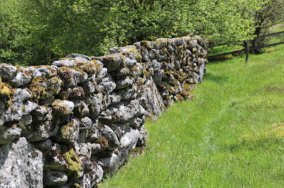
I like this stretch of stone walling because it seems, to me, that it is really bedded into the landscape. Of course, being covered in moss helps in this regard. At around this spot, we thought we saw a stoat but it very quickly scuttled off. If indeed it was a stoat, it was a rare sighting and a shame that the camera didn't capture the moment.
Just a section of the aforementioned wall. Built of 'moorstone' - taken from the fields and incorporated into the wall without any shaping. Good enough for keeping stock confined.
Our final mile or so was along the Hamlyn leat, originally built to take water to various mines and mills. Look into the distance and you can make out the line of the leat as it contours around Combestone Tor.
The leat serves many purposes, including providing a drink for the many ponies on this part of the moor.
As I mentioned earlier, there are lots of antiquities in these parts but most are not as easily discernible at this Bronze Age hut circle. Give it a few more weeks and it will be hidden by ferns.
Just a hawthorn tree, shaped by the prevailing wind coming from the west.
I'm glad they put a name plate on this because I was struggling to decide what it was. A very colourful addition to a cottage garden.
The nearby village/hamlet of Holne has an excellent community shop and tea room - just the place to head for after a walk. I was rather surprised that they had a 'DNP Information Point' with no pictures of me on display. I soon remedied that and now it's a proper 'DNP Information Point' and will tell visitors everything they need to know about me - and less.

Monday, 14 May 2018

Shetland Sojourn 2018: Part 5

Sometimes a day doesn't go quite as anticipated but there's always a Plan B...
Let's take a plane to Fair Isle and spend the day there. Sounds easy enough but we hadn't factored in the weather. Unfortunately we arrived at Tingwall airport (airstrip more accurately) to find that our flight had been postponed until at least noon because of poor visibility. Added to that was the potential problem of all of the relevant safety crew at the airstrip on Fair Isle attending the funeral of a well respected member of the community there. No safety crew: no landing. Given our limited time, Plan B smoothly swung into operation and we decided to go to Fetlar instead. Visiting Fair Isle would be a good enough reason to return to Shetland at some future date.
Getting to Fetlar is a bit of an adventure in itself and involves a couple of ferries. We drove north on the Mainland to Toft and then took the ferry to Ulsta on Yell. The time for our connection to Feltlar meant driving at speeds exceeding the limit to get to our next ferry from Gutcha in the north east of the island. Yell itself is pretty barren in the interior with most of the activity taking place along the coast. To be honest, we didn't see anything on Yell that yelled at us to stop.
It takes about 30 minutes to make the crossing from Gutcha to Hamars Ness on Fetlar. A friendly ferry-man, who lived on Fetlar, was quite incredulous that we were going there for the day. "There's nothing there", he said. As you can see the weather was rather overcast, which didn't bode well for our visit. Fetlar itself is the fourth largest in terms of area in Shetland and has a population of just over 60. Currently there are just four pupils in the primary/junior school: for their secondary education children have to travel to Lerwick and board for 5 days of the week.
Nothing fancy, just a few more Greylag Geese seen from the RSPB hide at Funzie Mires, near the Loch of Funzie. Probably everyone with an interest in birds will have heard of this place as, at one time, it was the only place in the UK to see the Red Necked Phalarope. Phalaropes are a strange group of pot-bellied, long-necked, short-legged, needle-billed waders that prefer to be in the water, rather than at the edge. Strange in that phalarope females are more brightly coloured than the males who spend their time incubating the nests so need to be more camouflaged. Strange in that there is a role reversal that goes further than just plumage, females will compete for nest sites at breeding grounds, choose a male and then defend him against other females. Once the chicks arrive, the female leaves the male to raise them on his own. Girl power, eh? And we didn't see any as it was too early for them to arrive at this site.
Funzie Bay with Nousta Ness to the left. It was quite a breezy day and the waves were building up. Not a place to strip off and go for a swim.as this was the North Sea, synonymous with cold water.
On the way back to the car from Funzie Bay we came across this snipe lurking in the grass. It's a Common Snipe that has the wonderful Latin name of Gallinago gallinago. In fact this is a member of a  local sub-species, Gallinago gallinago faeroeensis, seen in Orkney, Shetland, Iceland and the Faroe Islands. The sub-species seen everywhere is Gallinago gallinago gallinago, a name almost longer than the bird.
Brough Lodge is a 19th-century Gothic mansion and is, to some, a rather romantic ruin overlooking the Colgrave Sound. But its origins have a sinister undertone as it was built by the Nicolson family, who were responsible for clearing Fetlar of many of its inhabitants (better use the land for sheep rather than people). It has been disused since the 1980s and, allegedly, the Brough Lodge Trust has recently started work to restore the building. I say 'alledgedly' because it seems that a lot of public money has gone their way with very little to show for it. Certainly there were signs of building having taken place but it was clear that nothing had been done for quite a while.
To the left of the lodge is a castellated folly built on top of the site of an ancient broch.
On the way back to the ferry I took the opportunity to 'bag' the trig point on Kirk Knowe. A standard Hotine column type built inside an old stone structure of some sort. There are 4 trig points on Fetlar, which strikes me as a lot for such a small place, and Kirk Knowe is the most accessible of these. I have read that some people go especially to Fetlar to 'bag' all four in a single day. Nice thought but there would have been mutiny in the ranks if I had suggested that.
The views from Kirk Knowe would, on a clearer day, be far reaching but today? Only as far as Brough Lodge, with the misty hills of Yell in the background.
Almost our own personal ferry as we made our way back from Fetlar to Unst, then to Yell and back to Mainland via the final ferry of the day (and have I mentioned the generous discounts for those over a certain age?). Once off the ferry at the Unst, we drove about 2 miles up the road and decided that the lure of fish and chips at Frankie's in Brae on the Mainland was irresistible. So we turned around, got back on the ferry and crossed to Yell. A mad dash across Yell got us to the terminal in good time to catch the next ferry across to the Mainland and then it was off to Frankie's. He did not disappoint.