Thursday 18 October 2018

Out on the moor again

Hooray. Back on Dartmoor for a just-under 7 miler in glorious weather. Clear skies (mainly) and great panoramic views. We started and ended the walk in a car park near Whiteworks, about a mile onto the moor from Princetown - home, of course, of Dartmoor Prison. Here are a few random photographs to add to my collection.

You may be thinking "what a strangely shaped route?". And you would be correct but I'm far too diplomatic to say why. Not that this detracted from the pleasure. Far from it as the added air of mystery was a bonus.
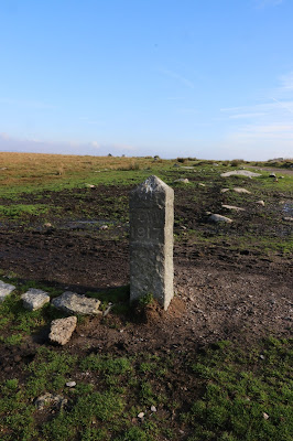
You can just make out 'PCWW 1917'. This is one of the boundary markers for the water catchment area for Burrator Reservoir, which, I estimate, is about two miles from this spot.
Before the reservoir was built, water was taken to Devonport via this eponymous leat. It was built in the 1790s to take water to Devonport and its Royal Naval dockyard. Plymouth was supplied by Drake's Leat. Both leats were 'retired' when the reservoir was built and Devonport was incorporated into the City of Plymouth (along with Stonehouse).
Over its original 28 mile length, the leat fell from a height of about 1390 feet to a level of about 130 feet i.e. it descended 1260 feet, giving it an average drop of 1 foot in 117 feet, less than a 1% slope. Quite an engineering feat over that distance, don't you think? And this gentle slope means that following a leat is always fairly level walking.
This is Hutchinson’s Cross, a modern wayside memorial cross which was erected in 1968 in memory of Lt. Commander B. Hutchinson’s mother who died in 1967. It has been suggested that this cross sits in a much earlier socket hole possibly filled by an ancient cross. On this side of the cross are the numbers 1887 – 1966 are inscribed denoting the ladies life-span and on the other (eastern) side, the letters S.L.H. standing for Sybil L (?) Hutchinson
Four cows and a Tree, giving me much more pleasure than ever Four Weddings and a Funeral did.
Looking towards Sharptor to the west. Blue sky. Vapour trail of a 'plane flying somewhere. Wherever it's bound, I'm not envious. I'm where I want to be.
Looking along the Down Tor stone row. These place are so atmospheric and, unlike Stonehenge, the monuments are not protected and you can touch them, run your fingers over them and connect with them. These were made by someone living and breathing 4000 years ago. Be amazed.
With the stone row and circle to myself, I set about wandering around the stones and chatting to the grazing Dartmoor ponies - just out of shot. We, as in us living in 2018, don’t really know the true meaning of these monuments in granite. I like to leave the true meaning and history to my imagination at times - did our ancestors watch the setting sun in awe and the rising moon in wonder from these markers. I really don’t want to discover that they are, in fact, washing line standing posts where Iron Age underpants were hung out to dry. I want to let my imagination run as wild as the Dartmoor ponies. It's much more fun.
Just a tree on the side of Down Tor. Guess the direction of the prevailing wind! Why photograph trees on Dartmoor? Because there aren't that many of them and they deserve some recognition for their perseverance.
Cuckoo Rock, the meaning of which is subject to many myths and legends. Me? I subscribe to the view that it looks like an extremely misshapen bird standing upside down with its head firmly embedded in the ground. Or something like that. Nowdays the Rock is a mecca for free-climbing enthusiasts. But they weren't there today. Pah, Fair weather climbers.
It's not uncommon to see bits of iron poking out of rocks in the middle of nowhere. Usually these can be rationalised as being a fastening of some sort for a gate. Not so in this case as this just seem possible. Could it be one of the Dartmoor tethers? In days of yore, farmers would ride up onto the moor as far as they could with their horse. But there came a point when the horse could not go any further, in which case the farmer dismounted and tethered his steed to one of these. Obviously, this was only done on regularly frequented routes. Makes sense to me.
The abandoned farm at Deancoumbe. You can make out the foundation of the old mowhay - the barn that was lifted off the ground by granite posts to stop rodents getting at the grain. Some of these are shaped like mushrooms.
Hawthorn berries and hanging lichen. Xmas is coming.
Just look at how clear the water is in this stream. I'd have no hesitation in drinking it as it is.
Looking due south west, you can just pick out Plymouth Sound as a ribbon in the distance. Look very carefully and you can make out the lighthouse on the Eddystone Rock, roughly 10 miles offshore. The visibility must be around 25 miles at this point.
And for those with poor vision and don't believe that there's a lighthouse to be seen, look at this one from my 200mm lens.
Somebody has commented that I rarely show people in my posts. Well, here's the group I spent this 'life is good' day with.

No comments: