Saturday, 10 November 2018

Coastal Footpath: Tintagel Castle to Trebarwith Strand. Plus St Clether as a bonus

With the forecasters telling us about high winds and lots of rain, let's do the obvious thing and walk along a stretch of the Coastal Footpath. And very good it was, too. We do like these sorts of days, we do. There was a bonus at the end with an impromptu visit to the church and Holy Well at St Clether.
This was a circular route from Tintagel Church to Trebarwith Strand. Around 4.5 miles, taking in countryside and the coast. Bearing in mind the direction of the wind, we decided that the inland leg was tackled first so we could have the wind at our backs as we came up the coast. In the event, it was a sensible decision. The rain held off and, for most of the time, the wind was not so strong that it caused us any problems.
As we only multiply (two children, seven grandchildren), we felt we could ignore this sign at the entrance to the graveyard.
St Materiana's Church. The first church on the site was thought to be built in the 6th century and was founded as a daughter church of Minster in Boscastle which is even older. The current church here was built in the late 11th or early 12th century with the tower added in the 13th or 14th centuries.
St Materiana is thought to have been a Welsh princess of the 5th century, the eldest of three daughters of King Vortimer the Blessed, Not a lot is known about her and there is only one other church in Cornwall, Minster at Boscastle, dedicated to her. This is a detail from the stained glass window in 'her' church.
As for many, the Victorians had a hand in remodelling the interior but the rood screen is original and is a fine example of mediaeval carving.
This Norman font is thought to have been brought from St Julitta's chapel at nearby Tintagel Castle. There is a face at each corner, all similar but not identical. Who were they modelled on? 
The "herringbone" style of walling built with tightly packed alternating diagonal slate courses, is unique to this part of the world.  It is known locally as "Jack and Jill", "Curzy Way" or "Kersey Wave".  On a long wall, the herringbone sections are generally between towers of flat-laid slate which help to prevent the wall slumping sideways.
From a man-made pattern to a natural one - young mussels clinging to the rocks at Trebarwith Strand.
Access to the beach for launching vessels etc is via this channel cut out of the slate bedrock. Ponder a while on the effort needed to do this. Nowadays it's mainly used by surfers and windsurfers but there are a few local crabbers that use the slipway.
Gull Island (just one of many so named along the coast), just off Trebarwith. I read somewhere that, because of the generous supply of bird guano deposited on the rock, it's becoming quite a fertile habitat for Sea Samphire.
Waves breaking at the end of Penhallic Point where the cliff edge was trimmed to form a 100ft vertical face. Ships could lie against this face as there is a natural deep-water berth alongside the point and slate was lowered by crane down into their holds. A path from the top of the point zig-zags down to a grassy platform where the lifebuoy is visible. This, the path, not the lifebuoy, was used by donkeys for the transport of materials.
There are nine slate quarries along this stretch of the coastal footpath.  Quarrying began here in the early 14th Century and ended just before The Second World War. The slate was exported from Tintagel Haven and later from boats moored along Penhallic Point. The crumbling stone walls and the outlines of buildings are the remnants of Bagalow quarry.  It is one of the smaller coastal quarries in this   area and dates back to at least the 1800s. The quarry face runs from sea level all the way to the top of the cliff where there are remnants of a powder magazine  and a horse whim used to haul the slate up from the quarry face. You can also make out some scullocks. What are these? Read on...………….
  In Lanterdan quarry there is this very distinctive pinnacle of rock, left behind as the slate in this was not of a sufficiently good quality for use. These chunks of inferior-quality slate were known as "scullocks".
We did not see many other people out on the cliffs today and I think I'll try and catch this one up. She looks rather attractive and, who knows, she might come home with me.
Courting down't Gilla
adders meet
amidst the tab mawn
lover's end

We came across this engraved stone near the end of our walk. Another job for Mr Google and this is what he came up with:
"Individual stanzas of the poem Amanda White wrote in collaboration with the residents of Tintagel were engraved onto ’touchstones‘ made from local slate which formed a circular walk linking the village to its main tourist attraction, Tintagel Castle. The touchstones are placed within the landscape of Tintagel in the places which directly inspired the words. Many of these contain information about the area's ecology and history. This stanza is placed at the corner of a field which is historically a place where lovers have come to court, and a place where adders are likely to be spotted. The poem also uses the Cornish name for Sea Daisy, tab mawn, and in doing so celebrates and preserves the local dialect".
"December 20th 1893: a mounted messenger galloped into Boscastle with news that a large ship was driving ashore, but by 4 pm the 1000-ton iron barque Iota of Naples had crashed under the great Lye rock off Bossiney Cove. Her crew leapt for the rocks, but two fell and were crushed under the barque’s bilges, while Domenico Cantanese, aged fourteen, was swept away. Only the body of the young cabin boy was recovered from the sea, he’s buried in the windswept graveyard of St Materiana Church Tintagel, where a wooden cross and a lifebuoy bearing his name and ‘Iota, Napoli, 1893’ still marks his grave".
This intriguing epitaph prompted a quick visit to Mr Google, who came up with this snippet from his wife, Lynne: "He died suddenly in the gym whilst training and wouldn't have known what was happening. We had no signs. The day he died he`d sat with me and told me how happy he was and how peaceful his life was with me, then went into the gym, finished his training, wrote in his book ( he documented every training session, which he dedicated to either people he knew or Stoke City), then died! Tans is buried here in Tintagel at St Matriana's looking over the cliffs of King Arthurs Castle, a place he really loved! The lads from Powerhouse came down to carry his coffin. He was buried with his Stoke scarf and his training belt!"
I won't go into the details here but the placement of this War Memorial was subject to much heated discussion between the various churches and chapels in Tintagel. It was not a time of great unity.
The church and holy well in St Clether are dedicated to Saint Cleder (or Clederus), one of the twenty-four children of Brychan. The church is of Norman origin, with a 15th century tower and (apart from the tower) was rebuilt in 1865.
Brychan was a legendary Celtic king (originally born in Ireland) who ruled over Breconshire in South Wales and was viewed as the father of the Celtic saints. Several mediaeval manuscripts state that he was married three times but the numbers of children vary from 12 to 63 with 24 being the most commonly reported number. There is also little agreement in the lists of names between Cornish and Welsh manuscripts. It is thought that the list of his children may have grown over time as more people claimed themselves or their local saint to be descended from what was seen as the holy family. Most of his children were reported to have evangelised Cornwall and North Devon, with many of the churches dedicated to them. Consequently, many of the place names in North Cornwall (St Teath, St Mabyn, St Endellion, St Minver, St Clether, Egloshale, Egloskerry, Advent, Morwenstow, Lelant etc) are associated with the names of his children.
St Clether as depicted in a very luminous stained glass window in the church.
Just a couple of days before Remembrance Sunday and a memorial window has been prepared. Simple but effective.
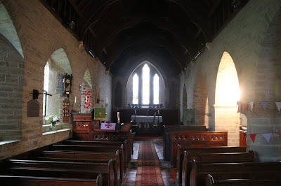
Remodelled by the Victorians but still very atmospheric. The ceiling line felt quite low and gave the interior a very comfortable feeling.
The well-house covering the holy well of St Clether, a pleasant 1/2 mile stroll near the Inny from the church
It is reputed that St Cleder built his hermitage by a spring in the Inny valley, and erected the 5th century granite altar which can still be seen there. The chapel was originally the village church until the Normans built one, on the site of the present church, in the 12th Century. In the 15th Century, the chapel and well were altered so that the water from the holy well ran through the chapel (past the relics of St Cleder behind the altar) and into the well at the front of the chapel (bottom right on the building) where it would be collected by pilgrims. The flow past the relics was thought to increase the healing power of the water. By the end of the 19th century, the chapel was in ruins, with only the altar and some walling remaining, but was rebuilt around 1900.
The altar which has been there for some 1500 years.
 

No comments: