One of the best places to see bluebells locally are the woods just by Burrator reservoir. And we headed there with one of our walking groups this week. The weather forecast was abysmal and it certainly lived up - or down - to our expectations. Because of the lousy weather, I did not risk taking my usual camera but it was an ideal opportunity to see just how waterproof the casing for my mobile phone was. Although some of the images which follow are somewhat distorted by rain on the lens, the casing passed the test.
 |
| We began and ended at the Burrator dam and basically took the footpath around the reservoir, before heading for lunch at Sheepstor church. We then walked through Burrator Woods to Meavy and back to the starting point. My GPS clocked up a very wet 6.7 miles. |
 |
| Hardly the best of views across the reservoir. There's nothing like a clear day for a walk. |
 |
| The overspill from the reservoir framed by some rhododendrons. |
 |
| Not a waterfall but water from the Devonport Leat discharging into a pipe and then running down into the reservoir. The Leat is was constructed in the 1790s to carry fresh drinking water from the high ground of Dartmoor to the expanding dockyards at Devonport. |
 |
| A bluebell wood but not THE bluebell wood. But, with all the rain, it was tempting at this point to say "OK, we've seen the bluebells so let's get back to the cars". But we didn't. |
 |
| Very wet but enjoying being out - and that's after about 10 minutes into the walk. |
 |
| Dining al fresco. There's something oddly enjoyable about watching the rain splash into your mug as you are drinking your tea. And below, a babbling stream. |
 |
| This is how I like my car parks on Dartmoor - completely empty. Only determined walkers go out in conditions like these. If I thought about it, I could be quite snobby about fair weather walkers. What do I mean? Could be quite snobby. I am. |
 |
| A leafy track, somewhat obscured by rain drops on the lens. I think this was the original track leading from Longstone Manor and was once cobbled. |
 |
| Longstone Manor is reputed to date from the 13th Century. It was tenanted until 1897. In 1898 the valley adjacent to the site was flooded to create Burrator Reservoir, during which part of the estate was also flooded and the main house abandoned. There are some vestiges of the house and farm buildings to be seen and a very rare 'wind strew' where crops were winnowed. Conditions weren't conducive to a wander around but here are a few granite troughs. All of them are micro-chipped as they are very desirable garden ornaments. |
 |
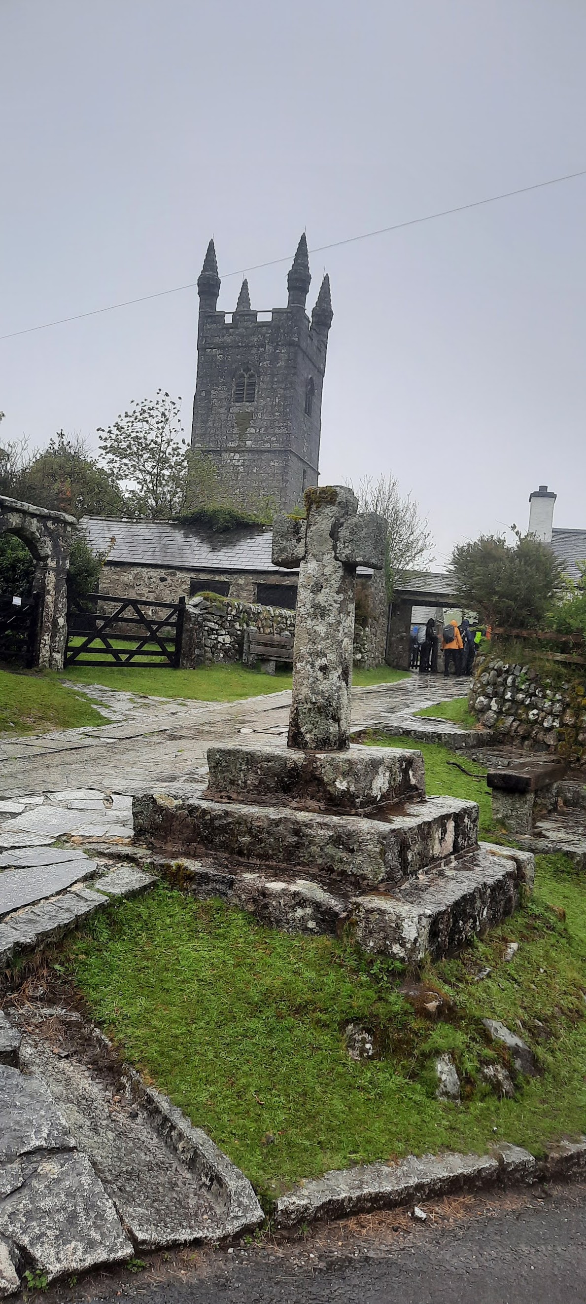
| A welcome and dry venue for our lunch stop - Sheepstor church, with Sheepstor cross in the foreground. No photographs from inside the church as access to the main body was prohibited due to Covid measures. |
 |
| What we came to see: the bluebells in Burrator Woods. Sadly looking rather weather beaten but still a delightful sight. |
 |
| The same woods with our group gingerly making their way down the rather slippery path. The yellow splodge of paint on the tree in the foreground is a waymarker. |
 |
| The fresh greens of the beech trees look rather mystical when captured through a rainy lens. |
 |
| Yeo House, restored and looking good. The last time we came this way it was not in quite this state. The Wisteria above the porch is coming into bloom. The inscription 'IW 1610' refers to John Woolacombe, believed to have been a tin mine owner of Sheepstor parish. |
 |
| Marchant's Cross, about which not a lot is known. Certainly medieval and probably located along routes that were once of significance, either for commercial or religious purposes. In fact, there is a theory that the name is derived from Merchant's. |
 |
| Bluebells on a hedgerow on the lane into Meavy, |
 |
| Part of the now redundant Drake's Leat, constructed in the late 16th century to tap the River Meavy from which it ran 17.5 miles to supply Plymouth with water. It began at a point now under water at Burrator Reservoir, from which its path now emerges some 10m lower than the typical reservoir water level. It was one of the first municipal water supplies in the country. The stone to the left is a Plymouth Corporation Water Works (PCWW) marker, dated 1917. |
 |
At the end of our walk, the view across the reservoir was a little clearer than when we arrived. And the rain had stopped, for a while at least. We could tell that the weather had been bad because there was no sign of the usually ever-present ice-cream van.
And below are two short clips of the water flowing down the overspill, the second of which is in slow motion. Why? Because I could. |


No comments:
Post a Comment