Showing posts with label Warbstow. Show all posts

Saturday, 24 June 2023

A walk with two churches, two crosses and a hillfort

This walk started and ended in the shadow of Warbstow Bury (more of that later) and was mostly within the Parish of Warbstow, a wholly rural and agricultural parish. Off the beaten track and with a nice isolated feel. It has an unusual claim to fame as it is one of the few in the country to still have an 'exclave' - an island of the parish in another. In this case, the hamlet of Canworthy Water is surrounded by Jacobstow parish and is separated from the main body of Warbstow parish by some 150 meters. An historical oddity, the origins of which I just cannot find. That irritates me - bad show, Mr Google, bad show. I would guess that the truth lies with someone of note wanting to keep it within his or her control for some reason.

This turned out to be a 6.3 miler and the profile doesn't do proper justice to the ups and downs we encountered. A mixture of quiet country lanes, farmland, tracks and footpaths, spiced with a couple of churches, two mediaeval crosses and an Iron Age hill fort. All that and excellent weather. The only negatives were the less-than-adequate signposting and some blocked/non-existent stiles encountered at various points. But, in the grand scheme of things, minor inconveniences.
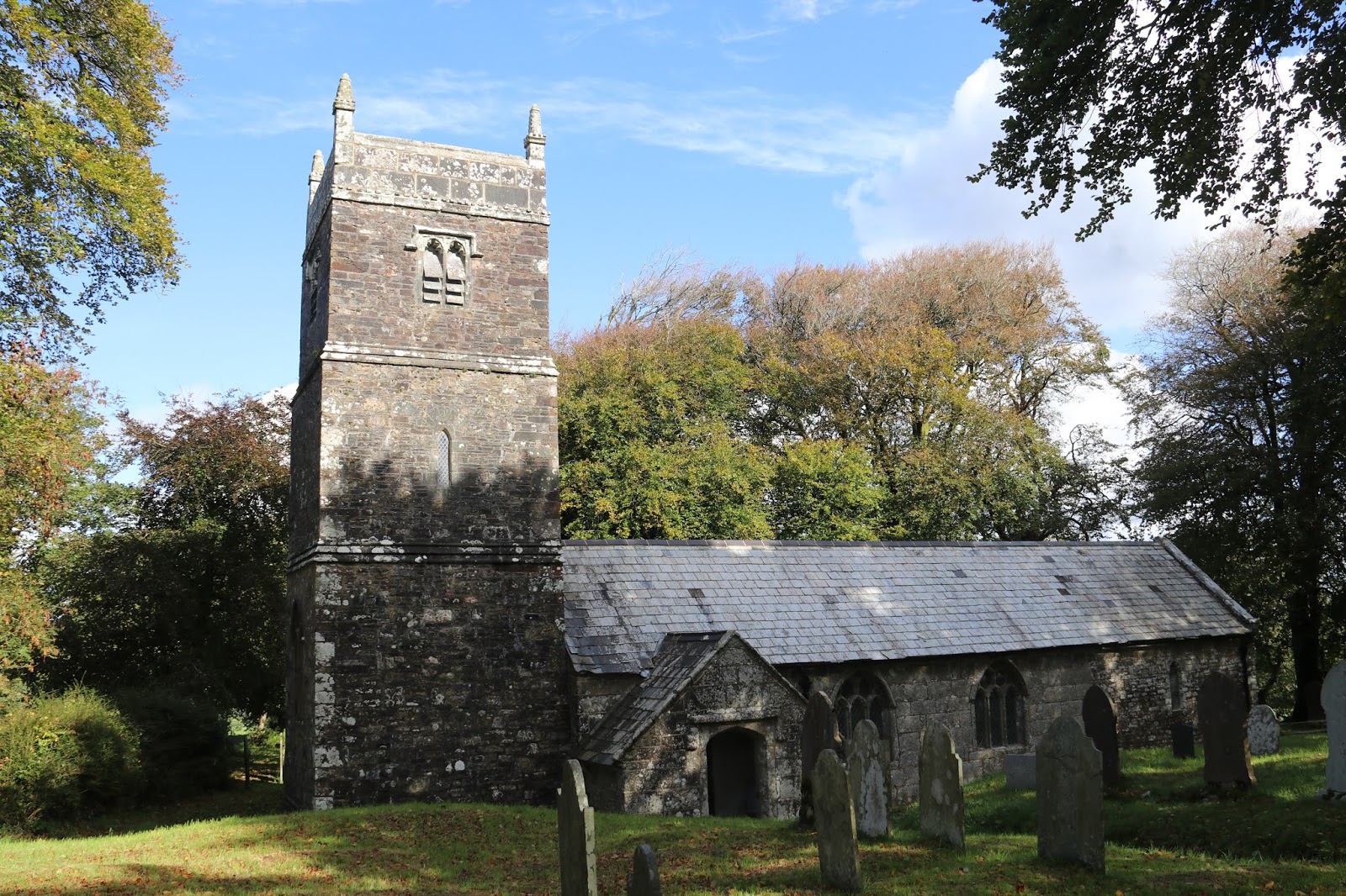
Church #1:  St Werburgh’s Church, Warbstow. What you see now is, apart from the obligatory Victorian tinkering, largely 15th century, with few remains of the two former buildings on this site - Saxon and Norman respectively. The church is dedicated to Saint Werburga, the daughter of  an Anglo-Saxon king of Mercia. She is also the patron saint of St Werburgh's church at Wembury. At one time, it was probably at the centre of things but, now, it lies in splendid rural isolation away from the main residantial settlements of Warbstow Cross and Carnworthy Water.
The interior of the church is quite plain and unadorned - no monuments, no stained glass windows, no elaborate altar. A simple building that has served the agricultural community for centuries. Apparently, the pipe organ is of note and came from the Masonic Hall in Bude in 1948. There's also an interesting font, the design of which reminded me of the one in Altarnun church - with a carved face at each corner. What was unique about this one is that the stem of the font seemed to reset on an upturned (earlier?) font basin.
The tiled floor of the church porch. A simple design but a lot of skill went into cutting the tiles into the exact lengths uniformly. There are a lot of them.
A partial list of the incumbents of the church. Of note are the effects of Cromwell's Commonwealth  - John Turner (ejected) and J. Harrison (intruded/imposed minister). But the list of names covers a turbulent part of England's history - the early ministers were members of the Catholic church, then we had disestablishment under Henry VIII, followed by the return to catholicism under his daughter Mary, then back to protestantism under his other daughter Elizabeth. Along comes the Commonwealth and the removal of the monarch and finally the re-establishment of the monarchy and Charles II. A simple list of names that becomes incredibly complex when the context is taken into account. At the heart of all this is the question: what impact did all these political changes have on the worship of those who attended this church?
The remnants of an old pole barn, probably dating from the late 1700s/early 1800s. The granite post in the middle is the eponymous pole.
Fortuitously we came across an intact version which shows what the one above would have looked like when it was functioning as a barn.
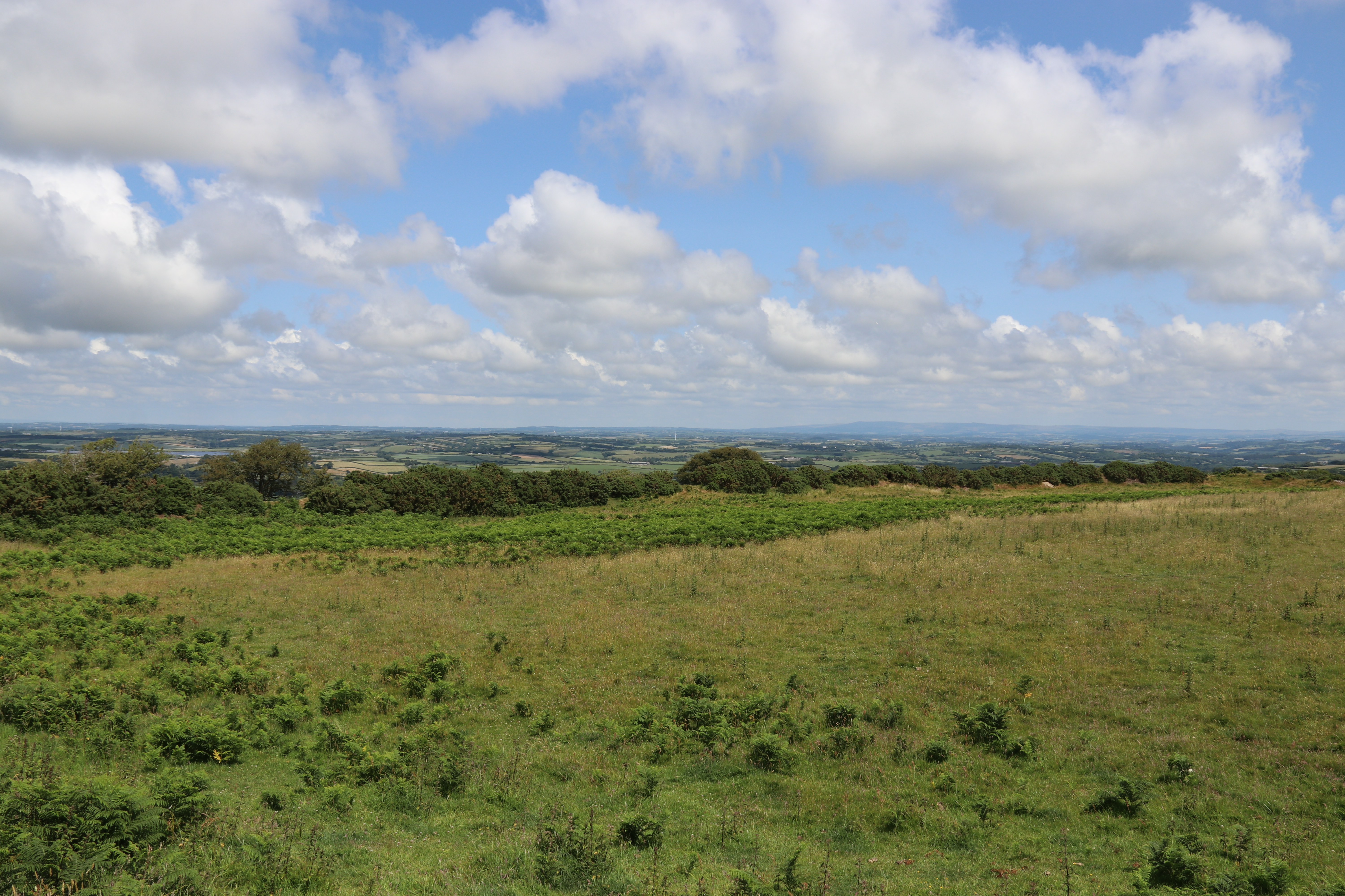
Throughout the walk we had views, views and more views. This one is looking due east, with Exmoor and North Devon in the distance.
Cross #1: This cross was found at Higher Youlton in 1976 buried upside down and used as a gate post. It was moved to its present position at Youlston farm some years later and reset on a new base stone.
Cross #2: This cross was originally used as a bridge over a nearby stream and was re-erected by the Old Cornwall Society in 1936 - as the little plaque to the right of it said. The stream forms part of the parish boundary so its present position is quite logical - such crosses were frequently placed at key junction points. And this route would have been an important link between the churches of Warbstow and Treneglos (united under a single vicar since the 1300s).
A disappointment: I was excited to come across a trough that housed, or so I thought, a very rare Clackworthy Dual-flow Throstle Valve. Unfortunately, I couldn't prise open the top cover to confirm this. So near yet so far. I would have been the toast of the Trough Spotters Club if only I could have taken a definitive photograph. But it was not to be. Perhaps I'll have to return with my largest crowbar and check it out.
A leafy lane, with dappled sunshine.
Church #2: St Gregory's, Treneglos. Guess what? It was closed and this might be permanent due to disrepair and safety concerns. There has been a church here since Saxon times; in the Domesday Survey of 1086, the church was given to the Priory at Tywardreath. The church was confirmed as the Priory's by Bishop Chichester on 14th February 1154. Originally, it was the 'mother' church to that at Warbstow and Warbstow was, in fact, a chapelry to Treneglos. The present church was rebuilt in 1858, and the tower, having become very dilapidated, was taken down in 1871 and completely rebuilt; its four bells were reused. Will the closure be permanent? It might become a so-called Festival Church, not open for normal services but open for weddings, baptism etc and special occasions.
The sculptured Norman tympanum, similar to other works in nearby churches such as Egloskerry, is described as "a conventional tree in the centre, with a pair of beasts having their tails bent round between the legs, and upwards across their bodies, placed symmetrically facing each other." The meaning may be found in the Psalms verse about the vine of Egypt: "The boughs thereof were like goodly cedars... The boar of the wood doth waste it, and the wild beast of the field doth devour it."
Some very intricate wood carvings on the beams in the porch. Hopefully they will be preserved for future generations to enjoy?
An early example of recycling? I wonder if this window, now in the walls of a pigsty, was filched from the church when it was being reconstructed? Or maybe it was retrieved from a builder's skip when they threw it out?
The latest cost cutting measures for public conveniences by English Heritage.
The size of the Warbstow Bury hillfort means that it's impossible to get an image that does it justice.  Here's some information I've plagiarised from the English Heritage listing.
"Warbstow Bury (
above), a multivallate hillfort in north Cornwall, is one of the largest and best-preserved hillforts in the county. It is also known as ‘The Giants Grave’ after the legend that a giant that lived here was killed when the giant of Launceston Castle threw a tool at him. It also called ‘The tomb of King Arthur’ although there is absolutely no evidence whatsoever to substantiate this. It has two ramparts, with two entrances each, the inner one measuring 370 by 450 feet. The outer rampart averages 15 feet in height, with an external ditch 15 feet wide. After the abandonment of the hillfort in the late Iron Age, the site is unlikely to have been used frequently for anything more than the summertime grazing of sheep in the early medieval period. The inner-circle was used as a beacon for the jubilee of Queen Victoria celebrations in 1887."
The above begs the question about which is the largest hill fort in Cornwall - this seems to be Castell an Dinas. But there are a surprising number of hill forts in Cornwall, probably more than 80. Since they have their origins in the Iron Age there is little left for us to see except a circle of substantial stones or a series of banks and ditches. Some of them were built around quoits and barrows showing that they had a spiritual significance to the people as far back as the Bronze Age. Over time these locations were ‘fortified’ with ditches, ramparts and maybe wooden palisades and inside would have been round houses for people to live in. Although we refer to them as ‘forts’ the ramparts would likely have signified ownership of a property. Who knows if they were ever put to test in a combative sense. I guess we'll never know but they are impressive and thought provoking places to wander around.

Saturday, 24 October 2020

Around and about Warbstow

Another of a trio of recent walks and one we did with friends from Launceston - another North's Choice. And an excellent choice it was, too. As they live about 10 miles north of us, they are choosing routes in areas that we are not familiar with and that adds a lot of interest. This one started and ended in the shadow of Warbstow Bury (more of that later) and was mostly within the Parish of Warbstow, which has an unusual claim to fame. It is one of the few in the country to still have an 'exclave' - an island of the parish in another. In this case, the hamlet of Canworthy Water is surrounded by Jacobstow parish and is separated from the main body of Warbstow parish by some 150 meters. An historical oddity, the origins of which I just cannot find. That irritates me - bad show, Mr Google, bad show. But it didn't spoil my/our enjoyment of the day. The photographs will show what I mean.
This turned out to be a 6.5 miler and the profile doesn't do proper justice to the ups and downs we encountered. A mixture of quiet country lanes, farmland, tracks and footpaths, spiced with a couple of churches, some mediaeval crosses and an Iron Age hillfort. All that and surprisingly very little rain.
Yet another use for tyres. A necklace to hold a tarpaulin down. Typical farmer's ploy - never spend any money when you can botch for free. I've definitely got some farmer's blood flowing through my veins. Nothing pleases me more than fixing a job with something from my seemingly inexhaustible supply of 'things that might come in handy one day'.
Church #1:  St Werburgh’s Church, Warbstow. Unfortunately closed due to Covid but one to visit when the virus cloud passes. What you see now is, apart from some Victorian tinkering, largely 15th century, with few remains of the two former buildings on this site - Saxon and Norman respectively. The church is dedicated to Saint Werburga, the daughter of  an Anglo-Saxon king of Mercia. She is also the patron saint of St Werburgh's church at Wembury that I've written about before.
They (who are they?) say that no two stone stiles in Cornwall are exactly alike and I can quite believe that as we've encountered many of them. This one is a fine example of a 'coffen' stile, usually written incorrectly as “coffin” stile, and is named after the Cornish word 'coffen' meaning a man-made hole in the ground. This refers to the stile's construction with a pit, not to the ease with which men can carry a coffin across it. Although the stile sometimes has a stone shelf alongside for a coffin (or any other burden for that matter) to rest on while the bearers got their breath back, this is not the source of the name, though presumably the English word coffin is from the same ancient root. Most coffen stiles are associated with 18th and 19th century country mansions or wealthy manor farms and with churches, being convenient for ladies with their long dresses, as the stile, a fore-runner of the modern cattle grid, is walked across, not climbed. Others were built wide enough for a worker carrying two pails with the aid of a wooden shoulder-yoke. Sometimes they were built when an ancient packhorse route was converted to a footpath, after a carriage road was opened.
I think this bracket fungus is Chicken of the woods (Laetiporus sulphureus) but I would welcome being corrected.
This cross was found at Higher Youlton in 1976 buried upside down and used as a gate post. It was moved to its present position at Youlston farm some years later and reset on a new base stone.
This cross was originally used as a bridge over a nearby stream and was re-erected by the Old Cornwall Society in 1936 - as the little plaque to the right of it said. The stream forms part of the parish boundary so its present position is quite logical - such crosses were frequently placed at key junction points.
Panoramic views all the way around on this walk. This is a very sparsely populated area and, in many ways, is quite remote. In the distance, the high land of Dartmoor can be made out.
My fungi identification book points me in the direction of Many-zoned Polypore (Coriolus versicolor) for this one. Looks reasonable to me.
I presume that, at some stage, the occupant of the caravan will realise that this isn't the best place to be a fisherman. The high tide never quite gets this far so launching the boat might pose a few problems.
Church #2: St Gregory's, Treneglos. Guess what? It was closed and is added to the list for a revisit. There has been a church here since Saxon times; in the Domesday Survey of 1086, the church was given to the Priory at Tywardreath. The church was confirmed as the Priory's by Bishop Chichester on 14th February 1154. The present church was rebuilt in 1858, and the tower, having become very dilapidated, was taken down in 1871 and completely rebuilt; its four bells were reused.

The sculptured Norman tympanum, similar to other works in nearby churches such as Egloskerry, is described as "a conventional tree in the centre, with a pair of beasts having their tails bent round between the legs, and upwards across their bodies, placed symmetrically facing each other." The meaning may be found in the Psalms verse about the vine of Egypt: "The boughs thereof were like goodly cedars... The boar of the wood doth waste it, and the wild beast of the field doth devour it."
VR? I wonder how many of this vintage are still around? And I wonder how many will remain in 5 or 10 years still with this livery? Precious few, I think.
Every war memorial is unique and every one has tales to tell. This one in Warbstow is no exception. Amongst the fallen of WW1 is Lance Corporal John Stapleton who had emigrated to Australia and was killed at Ypres whilst in the 55th Australian Infantry Battalion. One other thing about this memorial that's interesting is that it's the only one I've come across that names the women from the Parish who served in a war. In this case, WW2 and noted the service of seven women in the ATS, WAAF and NAAFI. It was good to see this.


The first photograph of this pair shows part of the surviving wall structure of Warbstow Bury. The size of this hillfort means that it's impossible to get an image that does it justice. Hence I thought that the photograph of the information board at the site would give a better idea of layout. Here's some information I've plagiarised from the English Heritage listing.
Warbstow Bury (
above), a multivallate hillfort in north Cornwall, is one of the largest and best-preserved hillforts in the county. It is also known as ‘The Giants Grave’ after the legend that a giant that lived here was killed when the giant of Launceston Castle threw a tool at him. It also called ‘The tomb of King Arthur’ although there is absolutely no evidence whatsoever to substantiate this. It has two ramparts, with two entrances each, the inner one measuring 370 by 450 feet. The outer rampart averages 15 feet in height, with an external ditch 15 feet wide. After the abandonment of the hillfort in the late Iron Age, the site is unlikely to have been used frequently for anything more than the summertime grazing of sheep in the early medieval period. The inner-circle was used as a beacon for the jubilee of Queen Victoria celebrations in 1887.
The Bury really is an impressive site and, as we did not know much about it, came as a complete surprise. This image is taken across the breadth of the central portion and keen eyes will make out the mound in the centre. Mythology gives this as the site of the Giant's Grave but it is thought that it's most likely to be the remnant of a mediaeval pillow mound that housed rabbits. The rain clouds in the distance did not come our way, I'm glad to say.
The central portion at the top of the Bury, clearly showing its circular shape.
"And this is what we think of you".
Looking north from the Bury towards Exmoor and the North Devon coast. We could just make out Lundy Island.