 |
| Widemouth Bay from our starting point. The far headland is just about where our last leg of the coastal footpath will end. Keen eyes will make out the satellite dishes of GCHQ Bude |
 |
| Typical geological formation for this part of the coast - the folds are called chevrons apparently. |
 |
| Where we've come from on the right and where we are going on the left. The distances were about correct. |
 |
| And this is pretty much the whole of the route we took. Navigation on the coastal footpath is never difficult - just keep the sea to your right and you can't go wrong. |
 |
| A rather intricate handpost on a stile. I've never seen one like this before. It lead into one of those attractive grottos that we come across every now and again. |
 |
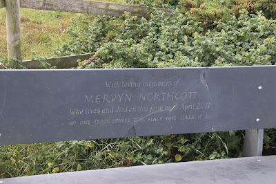
| The least I can do is to acknowledge Mervyn Northcott and his memorial bench at The Dizzard, the highest point on our walk. His obituary reads: |
 |
| The trig point at Dizzard Point. At that angle it was obviously never going to be any good at its original function. But that's not a problem, thanks to GPS and all that modern stuff. |
 |
| More chevrons. Even a non-geologist can appreciate the forces that produced these formations. |
 |
| The path down from the Dizzard. Vertiginous is a good word to describe it. Bloody steep are two more. |
 |
| Curious as ever, I tried to find out something about Bob and Joan Wilton and what their connection with the area was. For once, Mr Google let me down. |
 |
| Mrs P heading down into another hanging valley from Chipman's Point. We had worse descents on this walk. |
 |
| Looking down onto Crackington Haven from Pencannow Point, journey's end. We've often looked up at the point and wondered what it was like up there. Now we know. |
 |
| And this is the last stretch left to us. Sandy Mouth to Marsland. By all accounts, this is one of the most 'undulating' parts of the Coastal Footpath. |


No comments:
Post a Comment