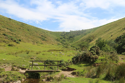
Most people passing through Merrivale nowadays probably have no idea of the complexity of the landscape that surrounds them. There are signs of at least 4000 years of human occupation and the walk we took this week touched on artifacts from both ends of the timescale.
Quid me anxius sum? (Alfred E Neuman, Mad Magazine circa 1956). Facio, ita.
Sunday, 21 August 2016
Thursday, 18 August 2016
A big bang in Plymouth
"Are you going to the Fireworks Competition in Plymouth?", she asked. "Take lots of photographs, please". Job done.
Sunday, 14 August 2016
Sunday Afternoon Stroll: 14th August 2016
A sunny afternoon and we took advantage of the weather and took a stroll along the banks of the River Lynher. Sometimes described as the forgotten part of Cornwall, it has long associations with the military because of its proximity to the Royal Naval dockyard at Devonport. A very pleasant 3 mile there and back linear walk, with a halfway break at the Carew Arms in Anthony.
Our start and end point was Wacker Quay on the Lynher. It is thought that Wacker is derived from Wicker and refers to its one-time willow industry. |
A nice collection of headstones in the graveyard of St James the Great, the parish church in Anthony. Unfortunately it was closed - on a Sunday! |
Looking north east, the two bridges at Saltash are visible in the distance. |
Saturday, 13 August 2016
A walk from Meldon Reservoir to the highest point on Dartmoor.
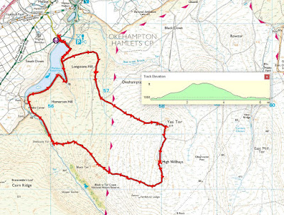
Whilst people in Brazil jumped, ran, swam, rowed and threw things, we went for a walk with our U3A Thursday group. No gold medals for us but a sandwich taken on a sheep-dropping bedecked tussock was an adequate reward for our efforts. We walked in the north moors of Dartmoor, beginning and ending at the car park close to the Meldon Reservoir, a couple of miles south of Okehampton. Our route took us straight up (and I do mean straight up) to Yes Tor, across the saddle to High Willhayes, the highest point on Dartmoor, and then back to our starting point via Black Tor and the western end of the Reservoir. The terrain was an interesting mix of footpaths, sheep tracks, an old military road and a fair amount of cross-country bog and tussock navigation, parts of which we would never have attempted if there had been more rain recently. As it was, there were lots of 'soakers' and muddy wet trousers in evidence. No turn on the podium as the National Anthem blared out at the end but some did manage to use the throne in the nearby public loos. An Olympian effort all round.
The map reference for our start and end point in the Meldon Reservoir car park was 56133 91791. |
Looking down towards the old railway viaduct near Meldon Quarry. Steep valley fed by many streams? Could be a good spot for a reservoir? |
Nothing out of the ordinary, just Common Bird's-Foot-Trefoil. But still a very attractive flower. |
An oak tree with an interesting bole down by the river. This woodland is a remnant of what used to cover large parts of the moor a long time ago. |
Slogging our way up the side of Yes Tor. It actually looks steeper than it was in practice but still good exercise. |
Looking back up to Black Tor, the third 'peak' we visited on our walk. In fact, a good day for 'tor bagging' - Yes Tor, High Willhayes and Black Tor. |
It's a good year for Rowan (Mountain Ash). Apparently the berries make a good jelly. |
Looking up a coombe. There is a path picking its way up the stream to the ridge but we took the one which came in from the right. |
My mushroom guide tells me that this is Panaeolus semiovatus or the Egghead Mottlegill mushroom. Non-psychoactive and non-poisonous. Apparently it is edible but hardly a mouthful for gourmets. |
Local eccentrics on the top of High Willhayes. OK, so you reached the cairn but there's no need to show off. |
Breathes there the man with soul so dead , who never to himself hath said . This is my own, my native land. (Sir Walter Scott). |
Subscribe to:
Posts (Atom)