Saturday 13 August 2016

A walk from Meldon Reservoir to the highest point on Dartmoor.

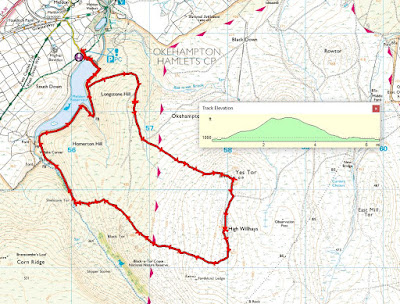
Whilst people in Brazil jumped, ran, swam, rowed and threw things, we went for a walk with our U3A Thursday group. No gold medals for us but a sandwich taken on a sheep-dropping bedecked tussock was an adequate reward for our efforts. We walked in the north moors of Dartmoor, beginning and ending at the car park close to the Meldon Reservoir, a couple of miles south of Okehampton. Our route took us straight up (and I do mean straight up) to Yes Tor, across the saddle to High Willhayes, the highest point on Dartmoor, and then back to our starting point via Black Tor and the western end of the Reservoir. The terrain was an interesting mix of footpaths, sheep tracks, an old military road and a fair amount of cross-country bog and tussock navigation, parts of which we would never have attempted if there had been more rain recently. As it was, there were lots of 'soakers' and muddy wet trousers in evidence. No turn on the podium as the National Anthem blared out at the end but some did manage to use the throne in the nearby public loos. An Olympian effort all round.
The map reference for our start and end point in the Meldon Reservoir car park was 56133 91791.
Looking down towards the old railway viaduct near Meldon Quarry. Steep valley fed by many streams? Could be a good spot for a reservoir?

Somebody else had that idea in the late 60s and, lo and behold, Meldon Reservoir came on stream in 1972. A very controversial decision as it impinged on the hitherto sacrosanct lands of the Dartmoor national Park. Nowadays I'm sure that visitors to the area wonder what all the fuss was about.

Two butterflies for the price of one! A little bit of sunshine and some flowers on the bramble and out they come. The larger one is a Silver Washed Fritillary and the one at the top is a female Meadow Brown.
The Silver Washed Fritillary. A little ragged in parts so it's been around a while. You can get a much better idea of why it's called 'Silver Washed' from its undersides. I spent ages trying to get a shot of it with its wings closed but it just wouldn't cooperate and there was a limit to how much time I was going to spend waiting.
Nothing out of the ordinary, just Common Bird's-Foot-Trefoil. But still a very attractive flower.
When I saw these diverging paths, I immediately thought of the lines from Robert Frost's poem 'The road not taken'. I won't pretend that I could remember it all but I could come up with:
Two roads diverged in a wood, and I,
I took the one less traveled by,
And that has made all the difference.

In a way, it's what I've always done throughout my life, been attracted to the path less travelled.
An oak tree with an interesting bole down by the river. This woodland is a remnant of what used to cover large parts of the moor a long time ago.
Slogging our way up the side of Yes Tor. It actually looks steeper than it was in practice but still good exercise.
Looking back up to Black Tor, the third 'peak' we visited on our walk. In fact, a good day for 'tor bagging' - Yes Tor, High Willhayes and Black Tor.
It's a good year for Rowan (Mountain Ash). Apparently the berries make a good jelly.
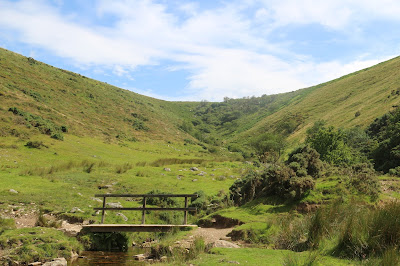
Looking up a coombe. There is a path picking its way up the stream to the ridge but we took the one which came in from the right.
My mushroom guide tells me that this is Panaeolus semiovatus or the Egghead Mottlegill mushroom. Non-psychoactive and non-poisonous. Apparently it is edible but hardly a mouthful for gourmets.
Local eccentrics on the top of High Willhayes. OK, so you reached the cairn but there's no need to show off.
The trig point on Yes Tor. At one time, Yes Tor was thought to be higher than High Willhayes, the 'peak' in the distance, hence the placement of the trig point. A remeasuring exercise reversed the order: High Willhayes comes in at 2034 feet and Yes Tor at 1999 feet.
Breathes there the man with soul so dead ,
who never to himself hath said .
This is my own, my native land.

(Sir Walter Scott).
 

No comments: